Subject: California
Period: 1856 (published)
Publication: Reports of Explorations and Surveys for a Railroad Route from the Mississippi River to the Pacific Ocean
Color: Hand Color
Size:
16.1 x 22.3 inches
40.9 x 56.6 cm
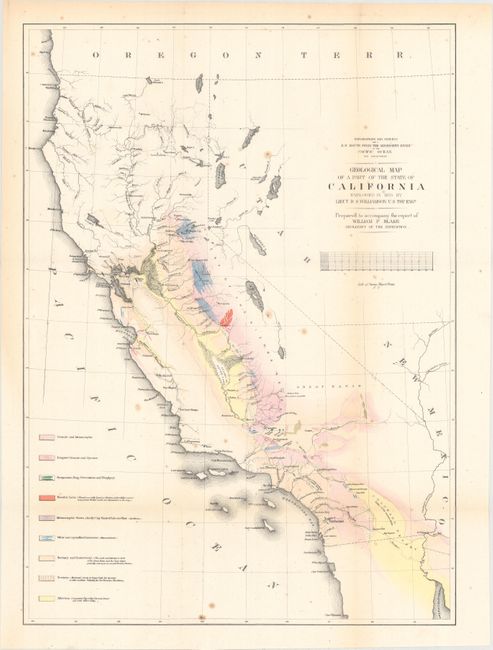
During the 1850s, the U.S. government sponsored an extensive series of expeditions designed to gather information on the vast new territories that had been acquired in western North America. The discovery of gold in California further stimulated westward traffic and heightened the need for a faster and more convenient way to bring the far-flung parts of the country together. In 1853 Congress commissioned the Army's Topographic Bureau to conduct a series of surveys to find a suitable route for a transcontinental railroad. There were six major expeditions; five of them covered the area between the Great Plains and west coast, and the sixth explored the coastal states of California and Oregon. All of these expeditions were accompanied by naturalists and artists to document the landscape, flora and fauna along the route.
The reports, maps and lithographs were published in the 13 volume report "Explorations and Surveys to ascertain the most practicable and economical route for a Railroad from the Mississippi river to the Pacific Ocean."
A majority of this map of California is colored to reflect geological knowledge and coded in accordance with a legend at the left. The legend identifies nine geological types as mapped by Lieut. R.S. Williamson of the Topographical Engineers. There are interesting details throughout, and especially along the American River. A huge Mono Lake is shown, but not Lake Tahoe; rather, in its place is a small lake named Lake Bonpland. In Southern California, Los Angeles, San Gabriel and San Pedro are located. Interestingly, the water between San Pedro (Long Beach) and San Diego is called "Earthquake Bay." Prepared to accompany the report of William P. Blake, Geologist of the Expedition. Lithographed by Sarony, Major & Knapp of New York.
This example has 1855 in the title instead of the more commonly seen 1853 date. The two are cartographically identical, but Marcou makes no mention of this later version.
References: Marcou & Marcou #678.
Condition: B+
Issued folding with light scattered foxing.