Catalog Archive
Auction 161, Lot 258

"[Untitled - Map Showing Routes of Oregon Volunteers During the Cayuse War of 1848] [in report] Letter from the Secretary of War ... Report of Capt. W.E. Birkhimer", U.S. War Department

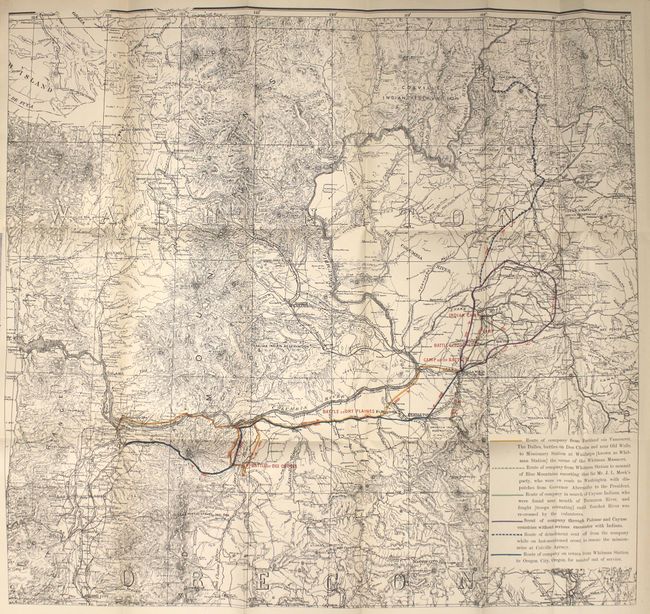
Subject: Northwestern United States, Indian Wars

Period: 1889 (published)

Publication: Sen. Ex. Doc. No. 6, 51st Congress, 1st Session

Color: Printed Color

Size:
23.4 x 21.9 inches
59.4 x 55.6 cm
Download High Resolution Image
(or just click on image to launch the Zoom viewer)

This map covers portions of Oregon and Washington along the Columbia River and shows the routes of Captain Hall's Company of Oregon Volunteers who fought during the Cayuse War, the first of the Indian Wars in the Pacific Northwest. The war was instigated by the slaughter of 14 missionaries at Whitman Mission near Walla Walla, and lasted for nearly eight years until the Cayuse Indians were eventually defeated. The 20 pp. disbound report was issued by Captain Birkhimer more than forty years after the war ended, and is based largely upon survivor testimony of the events. The report text credits the information on the map to Colonel Thomas R. Cornelius, a pioneer who served extensively in the Indian Wars and for whom Cornelius, Oregon is named.

References:

Condition: A

A crisp impression on a clean sheet with a few minor extraneous creases near the middle of the map image. Report text is also near fine.

Estimate: $250 - $325

Sold for: $325

Closed on 2/8/2017

Archived