Subject: Colonial Southeast United States
Period: 1744 (published)
Publication: Thomas Salmon's Modern History: or, The Present State of All Nations
Color: Black & White
Size:
10.9 x 8 inches
27.7 x 20.3 cm
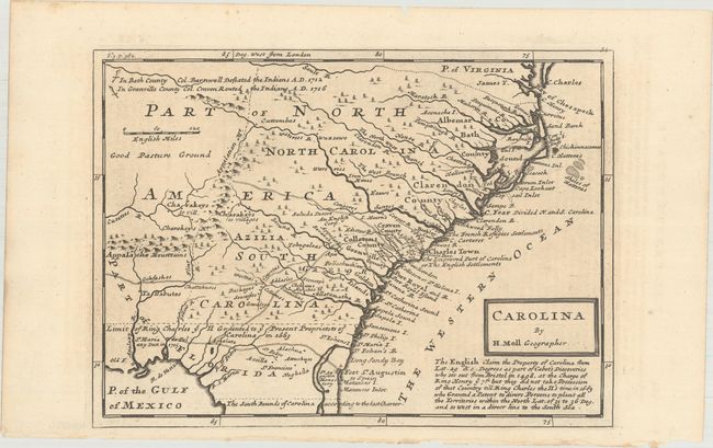
This is a very interesting map the Southeast, first published in Moll's Atlas Minor in 1729. The map extends from the mouth of Chesapeake Bay south to The South Bounds of Carolina according to the last Charter, which is in present-day Florida just south of St. Augustine. It extends inland to just west of the Apalaxy R. (Apalachicola River) and north to two battlefields of the Tuscarora War. The map is filled with good detail along the coasts, showing the locations of Indian tribes in the region, as well as several trails and trading routes into the hinterland. Several islands along the coast are identified by name for the first time on a printed map. The region of present-day Georgia is labeled Azilia for the aborted "Margravate of Azilia" of Sir Robert Montgomery, which was changed in later states of the map to "Georgia." Moll also shows the Seluda Desert, a remnant of the misconceptions perpetuated by John Lederer. A block of text below the cartouche describes the history of English claims to the region.
References: Cumming (SE) #206; Williams & Johnson #8.
Condition: A
A crisp impression on paper with a simple fleur-de-lis watermark and minor offsetting from an opposing page of text.