Subject: Colonial Mid-Atlantic United States
Period: 1671 (circa)
Publication: America...
Color: Hand Color
Size:
13.9 x 11.4 inches
35.3 x 29 cm
Montanus' work was perhaps the greatest illustrated book on the New World produced in the seventeenth century. It contained over one hundred beautifully engraved plates, views, and maps of North and South America. The plates vividly depict forts, festivals, occupations, Dutch fleets, battles, religious rites, and customs of the native inhabitants. This important work was translated into German by Olivier Dapper, and into English by John Ogilby. Several of the plates were later acquired by Pierre Vander Aa.
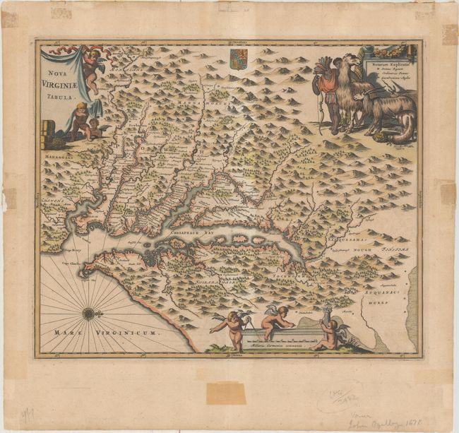
This is a very decorative, carefully made map based on the Hondius/Blaeu version of John Smith's prototype of Virginia and the Chesapeake Bay. It is beautifully engraved with mountains, rivers, and forests and provides a wealth of information concerning the Indian villages in the region. The title and distance scale cartouches feature putti and a scene at upper right features Native Americans with a llama, unicorn, and a fat-tailed sheep. This is state two, issued by Ogilby.
References: Burden #412; Tooley (Amer) p.168-9, plt. 76; Goss (NA) #38.
Condition: B+
A nice impression with light toning and a couple of soft creases. There are remnants of non-archival tape both on recto and on verso that had been used to frame the map, most of which is well away from the map image with the exception of one small piece on the verso that just enters the map border (but is not visible from the recto).