Catalog Archive
Auction 160, Lot 452

"A New & Accurate Map of Bermudas or Sommer's Islands, Taken from an Actual Survey; Wherein the Errors of Former Charts Are Corrected", Bowen, Emanuel
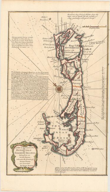
Subject: Bermuda

Period: 1747 (circa)

Publication: A Complete System of Geography…

Color: Hand Color

Size:
8.6 x 14 inches
21.8 x 35.6 cm
Download High Resolution Image
(or just click on image to launch the Zoom viewer)

This map was originally issued on a sheet also containing a map of St. Kitts, and has been trimmed along the right border to stand on its own. It is oriented with northeast at the top, and depicts the roads, towns and tribes on the island, as well as navigational hazards in the surrounding waters. There are several notes on the map giving more detail about the islands. Decorated by a baroque-style title cartouche.

References: Shirley (BL Atlases) T.BOW-2c; McCorkle (Geography Books) #17-34 (Vol II).

Condition: A

A dark impression on a clean sheet.

Estimate: $275 - $350

Sold for: $375

Closed on 11/16/2016

Archived