Subject: Texas & Oklahoma
Period: 1890 (circa)
Publication: Peerless Universal Atlas of the World
Color: Hand Color
Size:
13 x 19.6 inches
33 x 49.8 cm
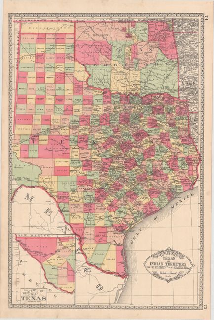
In Tunison's style, this is a finely lithographed map with original bright coloring. By this period most mapmakers had adopted printed color rather than the more labor intensive hand coloring employed here. It is decorated with a Victorian style border and title cartouche, which gives the population of Texas as 1,591,749 and no population reported for Indian Territory. At lower left is an inset "The Western Part of Texas on Reduced Scale." The panhandle of Oklahoma is Public Lands. Indian Territory is clearly divided into about 20 different Indian lands. Green County, originally established in 1860, is here unnamed and still part of Texas. It was abolished and awarded to Indian Territory by a Supreme Court decision in 1896. There is good detail of railroads with all stops located and named. Tunison's maps were printed on both sides; on the verso are single-page maps of Nebraska and Alabama.
References:
Condition: A
A colorful example on a clean sheet with one tiny fold separation confined to the left blank margin that has been closed on verso with archival tape.