Subject: Massachusetts
Period: 1930 (circa)
Publication:
Color: Printed Color
Size:
16.4 x 12 inches
41.7 x 30.5 cm
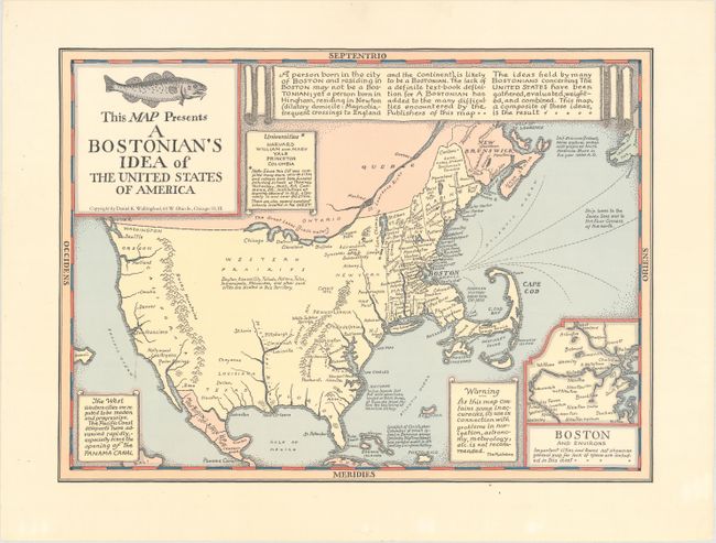
This novel map by Daniel K. Wallingford depicts the United States with an exaggerated Massachusetts in an attempt to illustrate "the ideas held by many Bostonians concerning The United States." In the comically distorted nation the map presents, the northeastern United States dominate while the rest of the country is mixed up and minimized: Florida stretches to the Mississippi, cities like Dayton, Kansas City, Indianapolis, and Milwaukee are noted to exist in the vast Western Prairies with no attempt to actually locate them, Reno is just north of the Mexican border, and Omaha is directly north of Denver. An inset at bottom right zooms in to show the "important cities and towns" around Boston, such as Dorchester, Newton, Waverley, and Charlestown. Numerous notes, several of them satirical, appear throughout the map, including the definition of a Bostonian, rumors of the West, a list of universities, a marker for where Christopher Columbus made landfall, and "Ship lanes to the Seven Seas and to the Four Corners of the Earth" radiating from Boston. The title cartouche is decorated with a large fish.
References:
Condition: A
A clean, bright, near fine example with a minor smudge in the Pacific Ocean and a minor edge tear in the blank margin at left that has been closed with archival tape.