Subject: Hawaii
Period: 1937 (dated)
Publication:
Color: Printed Color
Size:
35.5 x 17.4 inches
90.2 x 44.2 cm
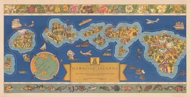
This vivid and graphic map of the Hawaiian islands was published by the Hawaiian Pineapple Co., Ltd. and drawn by Parker Edwards. The eight major islands are shown, with each filled with illustrations highlighting Hawaiian culture, including the "wettest spot on earth" on Kauai, a surfer off Waikiki Beach, hula dancing, a native luau, lava flows, a monument to Captain Cook's 1779 arrival on the island of Hawaii, and plenty of pineapples on the Dole Island of Lanai. Numerous volcanoes appear with their elevations on the island of Hawaii. The ocean is filled with various types of transportation, from a sailing vessel of the first inhabitants (dated 500 A.D.) and a ship of Spanish explorers (dated 1527) to a pineapple barge and an inter-island airplane. A large compass rose with a globe in the middle that centers on the Hawaiian islands and locates them as being 2,089 miles from North America, 5,000 miles from Australia, and 3,445 miles from Japan. Along the top of the sheet is a decorative border featuring a colorful assortment of local plant life, while the lower border includes a sampling of the bright, exotic fish that live around the islands.
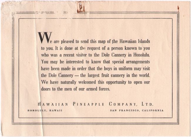
Also included with the map is a small thank you note (see images) from the Hawaiian Pineapple Company and the original mailing tube.
References:
Condition: A
A clean and bright example with a few tiny spots and one pinhole in the top blank margin.