Subject: Labrador, Canada
Period: 1860 (dated)
Publication:
Color: Black & White
Size:
26.3 x 14.9 inches
66.8 x 37.8 cm
The Office of Coast Survey is the oldest U.S. scientific organization, dating from 1807 when Congress directed that a "survey of the coast" be carried out. By 1836, it was called the U.S. Coast Survey and in 1878, the name was changed to the U.S. Coast and Geodetic Survey. Today the Office of Coast Survey is a division of the National Oceanic and Atmospheric Administration NOAA.
The survey teams, composed of civilians as well as Army and Naval officers, charted the nation's waterways and produced a wide array of reports, survey charts, hydrographic studies of tides and currents, astronomical studies and observations, and coastal pilots. These charts are an important record of the changing nature of the nation's coastlines. In additional to coastal charts, the U.S. Coast and Geodetic Survey produced land sketches, Civil War battle maps, and the early aeronautical charts.
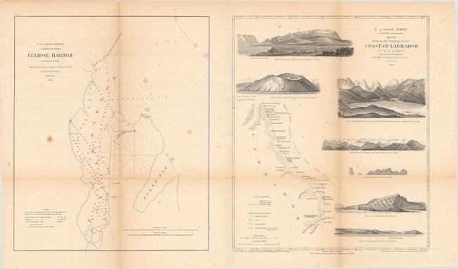
This attractive chart shows two maps on one sheet. The left half shows Eclipse Harbor and False Bay. Numerous soundings are noted as is Mt. Bache on Aulezavik Island. The right side of the sheet depicts the coastline from the Davis Strait to the Gulf of St. Lawrence. Includes seven attractive profile views and entrances. Drawn from the original sketches of Oscar Lieber, late state geologist of South Carolina.
References:
Condition: B
Issued folding with light scattered foxing, toning along several folds, faint offsetting, and a 2.5" fold separation on the Eclipse Harbor chart.