Subject: Russia
Period: 1787 (dated)
Publication:
Color: Black & White
Size:
47 x 21.9 inches
119.4 x 55.6 cm
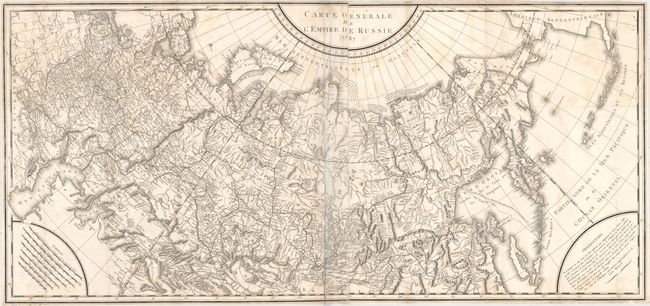
This large-scale map, printed on two sheets and joined, covers the entire Russian Empire from the Black Sea to Kamtschatka. It extends to include a portion of mainland Alaska and the Aleutian Islands based upon Russian sources. Several notations are presented along the Arctic Ocean including one along the northern coastline of Nova Zembla concerning the Dutch expedition led by Willem Barents in 1594-96. Features very good detail of topography and the river systems in the interior with seven distance scales located in the lower left corner. Engraved by Tardieu and issued in Peter Simon Pallas' Reise durch verschiedene Provinzen des Russischen Reichs (Journey through various Provinces of the Russian Empire).
References:
Condition: B
Issued folding with a few small splits at fold intersections, light scattered foxing, and faint offsetting. There are a few extraneous creases adjacent to the centerfold and the map has been trimmed close to the neatline all around.