Subject: Texas & Oklahoma
Period: 1864-76 (circa)
Publication:
Color: Hand Color
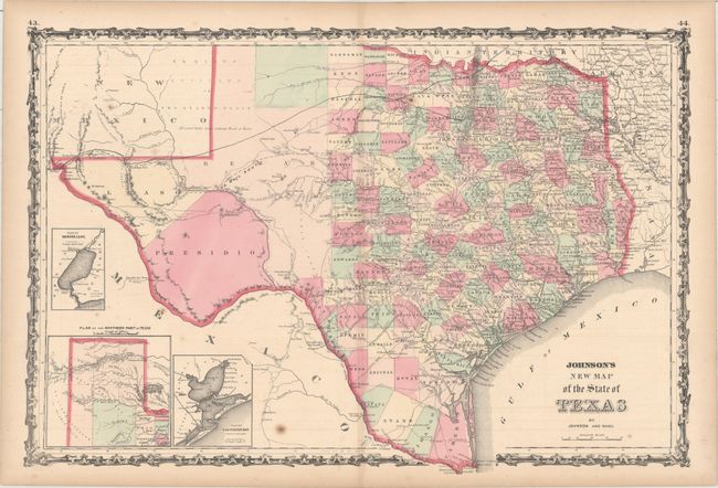
A. Johnson's New Map of the State of Texas, by Johnson and Ward, circa 1864 (24.6 x 16.4"). This large, handsome map shows county development mostly in eastern Texas and only the three large western counties of El Paso, Presidio, and Bexar in the west. The panhandle, noted as the El Llano Estacado or The Staked Plain (Elevated Table Land, without Wood or Water), includes a large section that is unorganized. Nice depiction of the wagon roads, many named, with several completed railroads including the Houston & Guaymas R.R. Insets include Plan of Sabine Lake, Plan of the Northern Part of Texas, and Plan of Galveston Bay. Decorative scrollwork border. Condition: There are a few spots of foxing in the image and light toning along sheet edges. (B+)
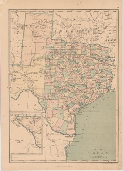
B. Map of Texas, by J. David Williams, circa 1873 (12.2 x 17.1"). This is an interesting map of Texas with superb detail of trails, ponds, springs, forts, and railroads. It shows county development and is filled with information on the region's resources (gypsum, salt, arable land, timber, sand, course grass, and forests labeled Mesquite Openings). The "Western Part of Texas" is shown in an inset on the same scale as the main map. Condition: Light toning with a few spots of foxing. (B+)
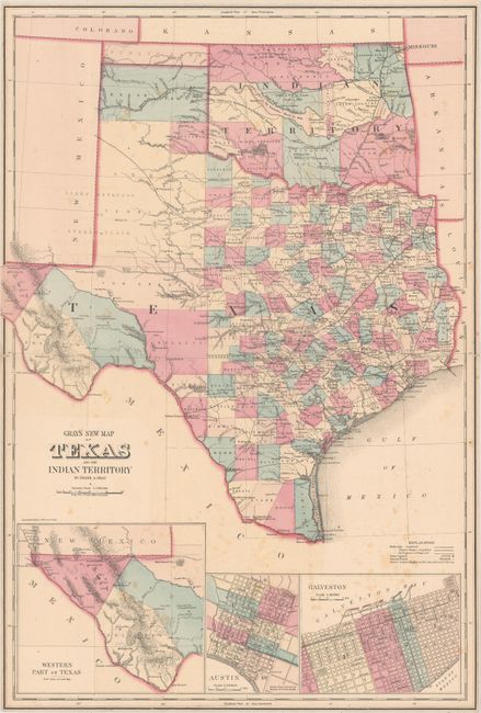
C. Gray's New Map of Texas and the Indian Territory, by Frank A. Gray, dated 1876 (16.3 x 23.9"). This terrific double-page map is filled with detail. It is the vertically oriented edition not to be confused with the horizontal edition from Gray's National Atlas. The state's rapid development is evident with only Young and Bexar Territories remaining unorganized. Wegefarth County, shown in Young Territory, was established in 1873 and abolished in 1876 by the legislature when they established the other Panhandle counties. Many railroads abruptly end between cities as the cartographer endeavored to show the exact progress to date. Details include numerous railroads, cities, towns, forts, and springs. Insets depict the Western Part of Texas, Austin, and Galveston. In Indian Territory the Public Lands are limited to the western panhandle. Condition: Light scattered foxing with margins trimmed close to the neatline. Tiny fold separations at left and right have been closed on verso with cello tape. (B)
References:
Condition:
See description above.