Subject: Northwestern United States
Period: 1865 (dated)
Publication: Johnson’s New Illustrated (Steel Plate) Family Atlas
Color: Hand Color
Size:
23.3 x 17.2 inches
59.2 x 43.7 cm
Although both dated 1865, these maps clearly depict different state boundaries and county configurations, illuminating the rapid development occurring at the time.
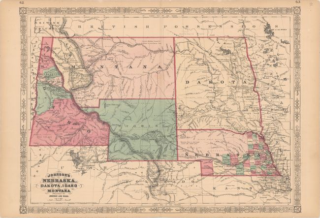
A. Johnson's Nebraska, Dakota, Idaho and Montana. This colorful double-page map shows a very early rendering of Wyoming Territory, organized in 1868. The territory's western boundary is not correctly formed; a pointed projection extends into present-day Idaho in the northwest, with Idaho occupying western Wyoming south of Jackson Hole. The map correctly delineates Montana which, along with Wyoming, was previously contained in a large Idaho territory. Dakota Territory, from which Wyoming was formed, remains undivided. There is excellent detail throughout with scores of place names, roads, watershed, topography, the Emigrant Road, forts, springs, routes of exploration and proposed railroads. The route of the Pony Express & U.S. Mail Route through Utah, Wyoming and Nebraska is delineated.
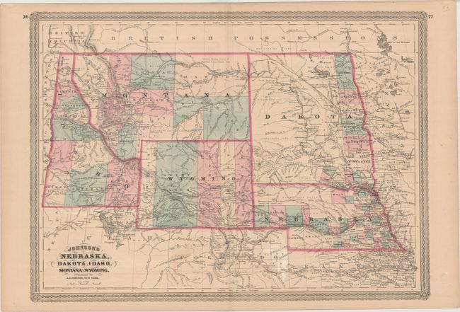
B. Johnson's Nebraska, Dakota, Idaho, Montana and Wyoming. This handsome map is centered on the newly created Wyoming Territory (1868) which shows county development circa 1870, with Uinta, Sweetwater, Carbon, Albany and Laramie, but prior to the establishment of Yellowstone National Park in 1872. Montana is shown, which, along with Wyoming, was previously contained in a large Idaho territory. Idaho Territory has ten organized counties. In Montana Pompey's Pillar is located as are the forts of C.F. Smith, Sarpy, Galpin, and more. Gold deposits are noted in south central Montana above Yellowstone, which will not appear for three more years. Excellent detail throughout with scores of towns and villages named, trails, wagon roads, immigrant roads, railroads, forts and more. Topography is shown via hachure and watershed is well developed. Features Johnson's later border.
References:
Condition: B+
Original color with very light toning and soiling. The first map has a few tiny tears in the bottom blank margin.