Subject: Exploration & Surveys
Period: 1757 (published)
Publication:
Color: Black & White
Size:
8 x 10.5 inches
20.3 x 26.7 cm
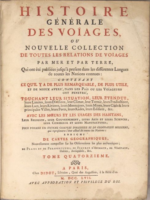
This is a very nice example of volume fourteen of Prevost's history of voyages, with maps by Jacques Nicolas Bellin. This volume focuses on the discoveries and establishments in North America and northern South America. The folding maps measure approximately 12 x 8" and include the following titles:
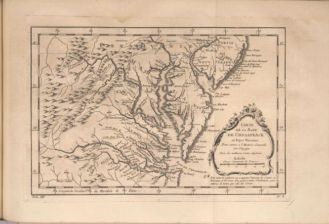
Carte de la Baye de Chesapeack. Finely engraved colonial map covering most of Virginia, Maryland, Delaware with a bit of Pennsylvania and New Jersey. The interior is fully engraved with mountains and great detail along the rivers. An early network of trails and wagon roads are delineated, plus watershed and some topographical information. It extends west to beyond Fort Cumberland and locates Annapolis, Fredericksburg, Williamsburg, Norfolk, and Philadelphia.
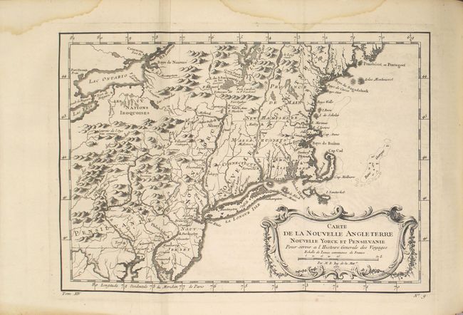
Carte de la Nouvelle Angleterre Nouvelle Yorck et Pensilvanie. This French & Indian War period map details the English colonies from Pennsylvania through to Castine, Maine, with their early boundaries. It is fully engraved with topographical features and includes many early place names. The colonies are shown confined east of the Allegheny Mountains with the Nations Iroquoises, Indian villages, and several French forts located west of the mountains. It extends to show Lake Ontario and most of Lake Erie.
Plan de la Ville de Boston et ses Environs. Attractive early plan of Boston and the harbor including Charles Town and Isle Ronde. It shows the street plan of the town and wharves, and locates gun batteries, powder magazines, Presbyterian churches, prison, town hall, windmill, and beacon. It indicates an offshore anchorage and the entrance channel and also depicts shoreline topography with the roads running down to the harbor. Large key at left lists sixteen important sites.
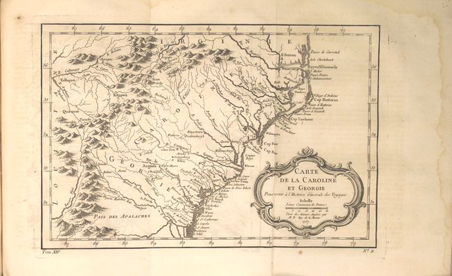
Carte de la Caroline et Georgie. Delicately engraved map of the colonies of Carolina and Georgia from Albemarle Sound to the Alatamaha River. It probably owes its origin to the 1752 map of the region by Emanuel Bowen. There are numerous English settlements along the coast and Indian villages are located throughout, including a number west of the Appalachian Mountains. There is more detail in the area west of the Blue Ridge than in many other maps of the period. It shows a rudimentary course of the Tennessee River in the northwestern section of the map.
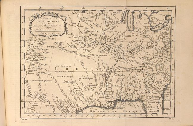
Carte de la Louisiane et Pays Voisins. Superb small map based on Delisle's map of the French colony of Louisiana. This finely engraved and detailed map of French Louisiana extends from the Great Lakes to the Gulf of Mexico and from Nouveau Mexique to Florida (not showing the tip of Florida). Many Indian place names, forts and early European settlements are shown. Nouveau Mexique in the far west includes Santa Fe and names the S. Jerome de Taos.
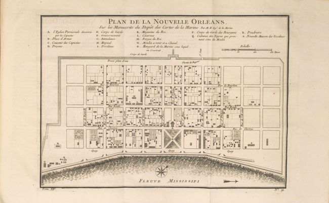
Plan de la Nouvelle Orleans. This attractive copper-engraved plan of the city of New Orleans details the city center including Bourbon Street. Individual buildings are depicted and keyed to a list under the title naming 18 buildings. The plan locates the quay along the Mississippi River, the canal, government buildings, church, prison, hospital, monastery, army & navy quarters. Bellin's plan was first issued in Charlevoix's History and General Description of New France in 1742 with later versions, such as this, used in several publications. The plan became the standard map of New Orleans throughout the eighteenth century.
Carte de l'Accadie et Pais Voisins
Carte de la Baye de Hudson
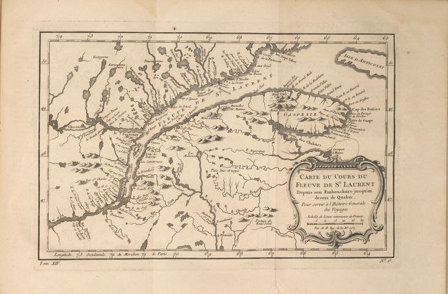
Carte du Cours du Fleuve de St. Laurent Depuis son Embouchure jusqu'au dessus de Quebec
Plan de la Ville de Quebec
Suite du Cours du Fleuve de St. Laurent Depuis Quebec jusqu'au Lac Ontario
Carte des Lacs du Canada
Carte de la Riviere de la Plata
Plan de la Ville de Buenos Ayres
Suite du Bresil Pour servir a l'Histoire Generale des Voyages (single page 7 x 9.2")
Suite du Bresil Depuis la Baye de Tousles Saints jusqu'a St. Paul (single page 7 x 9.2")
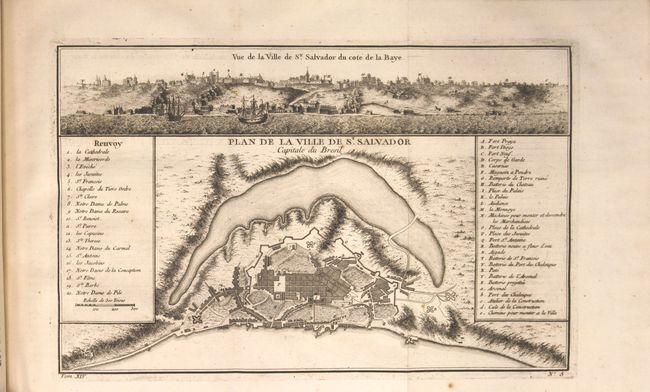
Plan de la Ville de St. Salvador
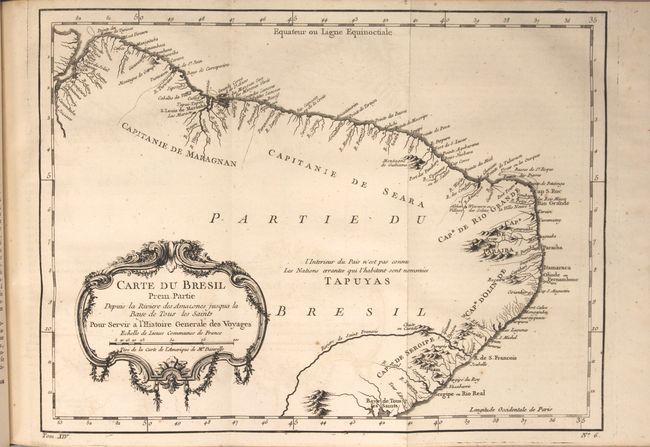
Carte du Bresil Prem. Partie Depuis la Riviere des Amazones…
Carte de la Guyane
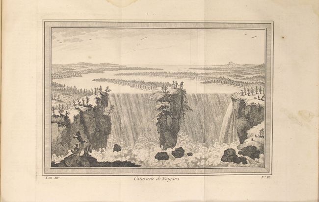
Published by Didot, the book is in full leather with gilt title and raised bands on spine. Quarto, viii, 763 pp. and 28 copper-engraved maps and plates, many folding and including the spectacular folding bird's eye view "Cataracte de Niagara."
References:
Condition: B+
The maps are very good to near fine with faint to light offsetting and occasional faint damp stains confined to the blank margins. Text is clean and bright with some occasional faint damp stains confined to the sheet edges. Covers are lightly worn with bumped and chipped edges, and the spine has a small chip at the head.