Subject: Asia
Period: 1730 (circa)
Publication:
Color: Hand Color
Size:
37.7 x 22.6 inches
95.8 x 57.4 cm
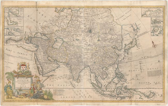
Although based on the "newest and most exact observations," this large format map of Asia depicts numerous geographical inaccuracies. The northeastern border of Asia is truncated, without any trace of the Kamtschatka Peninsula. Moll continues the speculation that Land of Iesso (Hokkaido) might be attached to the mainland and a partial coastline of Company's Land appears further east. The mythical Chaamay L. is shown in southern China with several rivers flowing west and south. The map includes navigational information, including the winds and currents related to the annual Monsoons in the Indian Ocean and the South China Sea. A note in the Pacific mentions an account of the Jesuits regarding the existence of 87 small islands located between the Philippines and the Moluccas, but reasons that since these islands were not mentioned by Dampier, that "we must suspend our belief of this relation." Seven small inset maps of commercially significant locations fill the top corners of the map: Hellespont (the Dardanelles), the Gulf of Smyrna (Izmir, Turkey), Bombay (Mumbai), the Hooghly River, a potential Northern Passage north of Russia, Chusan Island (Zhoushan Island), and Amoy Island (Xiamen). The opulent title cartouche features Asiatic treasures and trade goods, a figure riding an elephant, and a large coat of arms. The imprints of John Bowles, Thomas Bowles, Philip Overton, and John King appear to the right of the title cartouche. Printed on two sheets, joined.
**Please note that 50% of the consignor's proceeds of this map will go towards scholarships for history majors focusing in cartography, and disadvantaged students below the poverty line for books, fees, and tuition in Houston, Texas.**
References: Shirley (BL Atlases) T.MOLL-4b #4.
Condition: B
Original outline color with later color in the cartouche, light soiling, some staining to the right of the title cartouche, and a few tiny worm holes only visible when held to light. Issued folding with a number of short fold separations that have been archivally repaired, including a small hold along the left-hand fold in the area of present-day Sudan that has been professionally infilled with a minor amount of image replaced in facsimile. Remnants of hinge tape on verso along edges of sheet.