Subject: Southwestern United States
Period: 1860 (dated)
Publication:
Color: Black & White
Size:
34 x 28.5 inches
86.4 x 72.4 cm
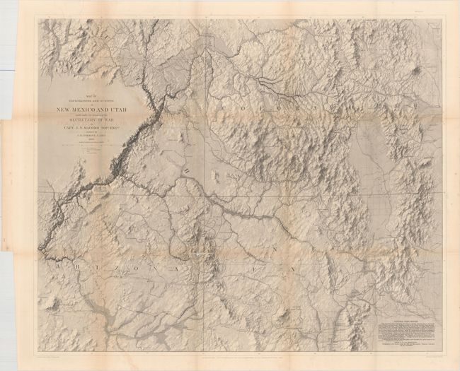
Very rare, large map considered by Wheat to be a landmark in the mapping of the region and "one of the most beautiful maps every published by the Army." According to Wheat there are several reasons for its importance. First, it is the first to show a trail to the junction of the Green and Grand Rivers. Second, he praises the map for its depiction of numerous routes of other explorers. Finally, it demonstrates the culmination of the process developed by Egloffstein to convey the idea of altitude. The process used a combination of extremely fine lines and applying acid to the plate for varying times, thus giving the map a remarkable 3-dimensional realism unmatched in the period. It is also the first to correctly establish the relationship between the San Juan and Colorado Rivers. The map covers Arizona, Utah, New Mexico and about 30% of Colorado. The map was issued in Capt. Macomb's very rare "Report of the Exploring Expedition from Santa Fe, New Mexico, to the Junction of the Grand and Green River", produced in 1860 but not issued until 1876 due to the Civil War.
References: Wheat (TMW) #983.
Condition: B
Issued folding with faint offsetting of the title and light toning along the folds. There are three splits at fold intersections that range in size from 1" to 4" with minute loss of image and one 6" separation along the left vertical fold.