Subject: United States
Period: 1853 (circa)
Publication: A Gazetteer of the United States of America
Color: Hand Color
Size:
40 x 21.5 inches
101.6 x 54.6 cm
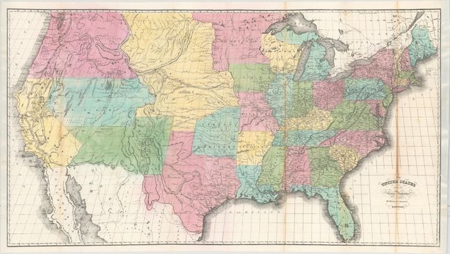
This large map is an early and fine example of American lithography. It features the large territorial borders characteristic of this period. Oregon occupies the entire Northwest, extending to the Continental Divide. A huge Nebraska Territory stretches from the Continental Divide to a large Minnesota Territory at the Missouri River. Utah and New Mexico Territories are shown at their largest extent. An oddly shaped Indian Territory without its panhandle extends north from Texas up to Nebraska Territory. The distances along the Oregon Route (Oregon Trail) are noted in miles beginning at Westport Landing. Several exploration routes are shown including Kearny's route to Santa Fe and on to the Colorado River. An Old Spanish Military Road from Santa Fe to San Antonio is delineated. Wheat notes that the map exhibits some of the features from Colton's map in the 1852 Horn's Guide.
References: Wheat (TMW) #787.
Condition: B
A clean and bright example with toning along several folds. Professionally backed with tissue to reinforce and repair several short fold separations along the right two folds with minute loss of image. Remargined at left and right.