Subject: Colonial Eastern United States & Canada
Period: 1777 (dated)
Publication:
Color: Hand Color
Size:
20 x 18 inches
50.8 x 45.7 cm
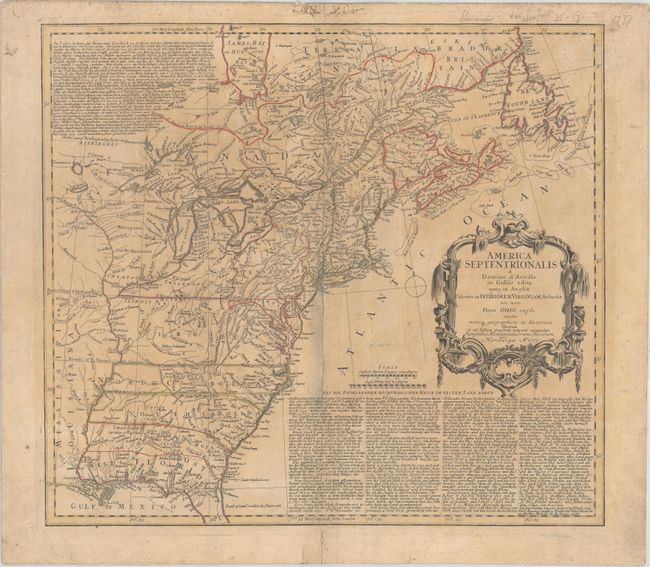
This is the Revolutionary War issue of Homann's map that was originally published during the French and Indian War in 1756 after Jeffery's map from the previous year. This edition includes several alterations and updates plus the line "et ad bellum praesentis temporis accomodata" added to the imprint. It shows the area from James Bay and Newfoundland in the north to northern Florida and the Gulf coast in the south, and depicts the British and French possessions during the first full year of the war. The western extent of the map is just west of the Mississippi River, and is called Mississippi or Louisiana. The boundaries of Virginia and North Carolina, shown with dotted lines, extend westward off the map. The boundary of New York still appears to cross Lakes Ontario, Huron and Erie to include the lower peninsula of Michigan, but the western extent is not clearly delineated. There is an early depiction of Georgia with its boundary on the Mississippi. The map is embellished with a large title cartouche. The extensive German text at upper left and lower right describes the British claims and French encroachments with historical context.
References: McCorkle #777.2; Sellers & Van Ee #69.
Condition: B
Original outline color on very heavy paper that has been reinforced along the edges on verso with old paper. There is light toning and soiling, a few minute worm tracks in the image, and a centerfold separation that has been archivally repaired.