Subject: North Pacific Ocean
Period: 1785 (circa)
Publication:
Color: Black & White
Size:
26 x 15.2 inches
66 x 38.6 cm
Captain James Cook (1728-1779) is best known for his three voyages to the Pacific (1768-71; 1772-75; and 1776-79). His discoveries radically changed the western understanding of the world in the late 18th century. He was the first to circumnavigate and chart New Zealand and provided the earliest European accounts of exploration along the eastern coast of Australia and the Hawaiian Islands. On February 14th, 1779, he was killed on Hawaii after attempting to kidnap the chief of the island.
Many contemporary accounts of Cook’s voyages, including charts and engravings, appeared in the late 18th century. The first official account of Cook’s first voyage was published in 1773 by John Hawkesworth in Volumes II and III of An Account of the Voyages Undertaken by the Order of His Present Majesty for Making Discoveries in the Southern Hemisphere... William Strahan and Thomas Cadell published the first official accounts of the second and third voyages in 1777 and 1784. Accounts of his exploration were subsequently translated into French, German, and Dutch.
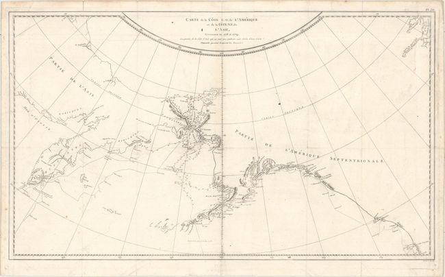
This large map is centered on the Bering Strait with soundings and dates that chart Cook's third voyage up the northern reach of the Pacific in his search for a Northwest Passage. Cook probed along the Oregon coast in bad weather to Nootka Sound, where he rested and refitted his ships. They sailed forth to the Alaskan and Chukotskiy peninsulas and from there into the Bering Strait. Cook reached 70° 41’ N before being forced back by the pack ice off Icy Cape. The expedition turned south down the Russian coast and then east to Norton Sound. Cook's journey then ended in Hawaii where Cook was killed in a dispute with the natives.
References:
Condition: B+
Issued folding and now flattened on watermarked paper. There is faint offsetting, a few tiny fold separations repaired on verso with archival material, and minor soiling primarily in the blank margins.