Subject: Southern Africa, Explorations
Period: 1858 (dated)
Publication: Petermann's Geographische Mittheilungen
Color: Hand Color
Size:
16.8 x 20.8 inches
42.7 x 52.8 cm
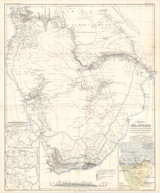
This very detailed map features the explorations of Dr. Livingstone with his probable routes (1841 - 1856) shown in red and extending from Cape Town through the interior and out to both coasts. The explorations of Gamitto (1831), Moffat (1854), Galton (1850-1851), and Anderson (1851-1853) are also delineated. The map is very finely engraved to show extensive watershed and topography with many villages named. Large inset at lower right uses color and line to identify the location of the Hottentots; Betschuana; Kifir; Neger-Stajmme; Gemischte; Betschuanen u. Kafir and other peoples. Three insets at left present the geography of central Africa per H. Kiepert, Nov. 1855; J. McQueen, March 1857; and D. Livingstone, Nov. 1857. At lower center is a geological profile of the continent with the legend identifying 10 types using different patterns.
Dr. Augustus Herman Petermann's Geographische Mittheilungen was the oldest German trade magazine dedicated to geography. First published in 1855, the magazine covered many of the important discoveries of the 19th and 20th century until its end in 1937. Published by Justus Perthes in Gotha.
References:
Condition: B+
Issued folding on a bright sheet with one tiny edge tear closed on verso with archival tape and a few light spots.