Subject: India
Period: 1756-1820 (published)
Publication:
Color:
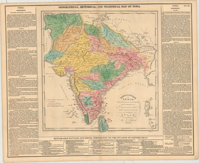
A. Geographical, Historical, and Statistical Map of India, by Aspin/Lavoisne, from Lavoisne's Genealogical, Historical, Chronological & Geographical Atlas, dated 1820, hand color (12.8 x 13.4"). This is the first American edition of this informative map of India, updated from the London edition of 1817 and published by M. Carey & Son. In addition to showing political divisions, towns, rivers, mountains, and other topographical features, the map notes the dates and locations of a plethora of battles and naval engagements as well as marking British possessions and dependencies. The map is surrounded by English text describing the nation's geographical features and history, with a list at bottom detailing the specifics of some of the battles shown in the map above. An alternate title, Hindoostan; or, India: Drawn from the Most Recent Authorities, for the Illustration of Lavoisne's Genealogical, Historical, Chronological, and Geographical Atlas, appears in a cartouche within the map. Originally engraved by Kneass and printed by T.H. Palmer. The full sheet with surrounding text, the sheet measures 21.6 x 17.5". Condition: Original color with minor toning along the centerfold, faint offsetting, a centerfold separation at top that just enters the neatline of map image, and another at bottom that enters about 2.5" into the text.
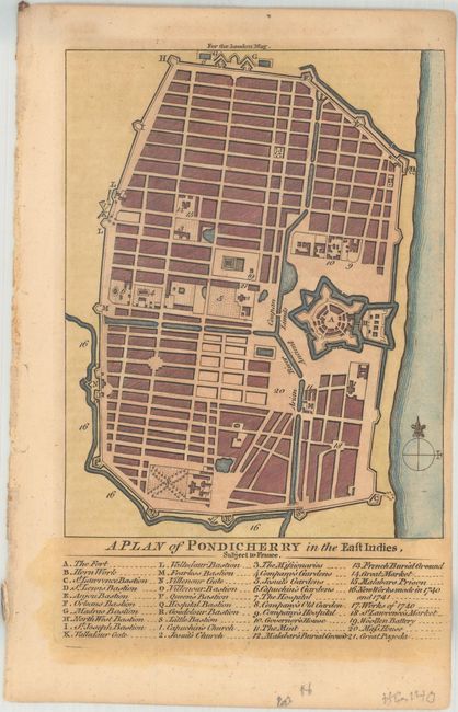
B. A Plan of Pondicherry in the East Indies, Subject to France, by Anonymous, from London Magazine, published 1759, hand color (4.6 x 7.0"). This small yet striking plan shows the city of Pondicherry in southeastern India when it was under French control. Beneath the plan, an extensive keys identifies sites of interest, including fortifications, churches, gardens, hospitals, the governor's house, and the Great Pagoda. Ref: Jolly #LOND-167. Condition: Lightly toned with a few binding holes in the left blank margin.
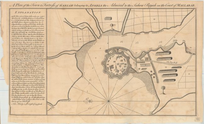
C. A Plan of the Town & Fortress of Garlah Belonging to Angria the Admiral to the Sahou Rajah on the Coast of Mallabar, by Anonymous, from Gentleman's Magazine, published 1756, black & white (17.5 x 10.1"). This sheet depicts the interesting layout of Vijaydurg Fort, established as the capital of his coastal territory by Kanhoji Angre, the admiral of the Marathas, in 1698. The chart features a detailed key at left explaining each delineation on the map, including the names of all buildings, such as the Admiral's palace (the largest building on the plan). The Angre clan lost control of Vijaydurg Fort to a British-Peshwa alliance in the early months of 1756 during the Battle of Vijaydurg. Ref: Jolly #GENT-101. Condition: A dark impression issued folding on watermarked paper with light offsetting and a binding trim in the left blank margin. There are a couple short fold separations confined to the blank margins.
References:
Condition: B+
See description above.