Subject: Gulf of Mexico & Caribbean
Period: 1780 (published)
Publication: Political Magazine
Color: Hand Color
Size:
25.2 x 11.6 inches
64 x 29.5 cm
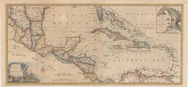
This detailed map of the West Indies, which Jolly calls “impressive,” extends to cover parts of North America, Central America, and the northern coast of South America. Several large islands make up Florida's southern tip with a note that de Soto landed on the western side in 1539. The map is filled with coastal place names and shows important rivers and mountains. An inset at top shows the harbor of Omoa (Honduras). Adorned by a decorative title cartouche. Published in the March 1780 edition of Political Magazine.
References: Jolly #POL-3; Phillips (Maps) p. 1058.
Condition: B+
A dark impression, issued folding with light toning and soiling and a few minor fold separations that have been archivally repaired.