Subject: World
Period: 1750 (dated)
Publication:
Color: Black & White
Size:
26.8 x 19.5 inches
68.1 x 49.5 cm
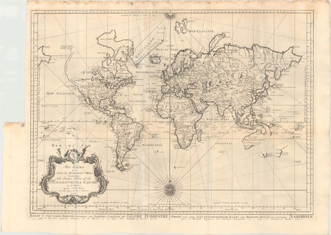
Bellin's popular world map is presented on Mercator's projection with two fine compass roses orienting the chart. North America is shown with a very pronounced River of the West connecting through a series of rivers and lakes from Lake Superior to the Pacific - representing the elusive Northwest Passage. A portion of the Asian coastline is depicted a short distance from the supposed western coast. The Russian discoveries in the North Pacific are not yet shown, although there is a note about the voyages of 1743. Able Tasman's new discoveries in New Zealand and Australia are shown. Australia is labeled Hollandia Nova with Nova Guinea linked to the mainland by the Carpentier coastline. Terre de Diemen, also labeled I. Tasman, is connected to the mainland by conjectural dotted lines. A large, decorative title cartouche completes the composition. Published by Peter de Hondt with alternate titles in French and Dutch in lower margin. Engraved by Van Schley.
References:
Condition: A
A dark, crisp impression on watermarked paper, issued folding. There are some damp stains along top edge of sheet, entering faintly into top of map. There are faint blue shadows along several folds that are caused by our scanner and do not appear on the map itself.