Subject: New England - United States
Period: 1828 (dated)
Publication: Report of the Board of Commissioners of Internal Improvement…
Color: Black & White
Size:
41.7 x 7.4 inches
105.9 x 18.8 cm
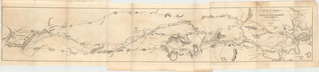
This rare map by James Hayward depicts the railway route from Providence to Boston in good detail showing topographical information, towns, buildings, rivers, bridges, and much more. It appears to show two proposed routes, both arriving in Providence. The northernmost route begins near the house of Madam Swan on the road between Roxbury to the South Boston Turnpike, and the southern route begins in Boston proper. This is the first entry in Modelski's "Railroad Maps of North America," and he notes that this is the earliest topographic map in the Library of Congress showing a railroad survey. This map was first published in the "Report of the Board of Commissioners, of Internal Improvement in Relation to the Examination of Sundry Routes for a Railway from Boston to Providence. With a Memoir of the Survey." Issued on three sheets and joined.
References: Modelski #1 (North America); Modelski #348 (United States).
Condition: B+
Issued folding with light offsetting and toning.