Subject: Cook Strait, New Zealand
Period: 1775 (circa)
Publication: Ausfuhrlich und Glaubwurdige Geschichte der Neuesten Reisen um die Welt...
Color: Hand Color
Size:
10.6 x 10.6 inches
26.9 x 26.9 cm
Captain James Cook (1728-1779) is best known for his three voyages to the Pacific (1768-71; 1772-75; and 1776-79). His discoveries radically changed the western understanding of the world in the late 18th century. He was the first to circumnavigate and chart New Zealand and provided the earliest European accounts of exploration along the eastern coast of Australia and the Hawaiian Islands. On February 14th, 1779, he was killed on Hawaii after attempting to kidnap the chief of the island.
Many contemporary accounts of Cook’s voyages, including charts and engravings, appeared in the late 18th century. The first official account of Cook’s first voyage was published in 1773 by John Hawkesworth in Volumes II and III of An Account of the Voyages Undertaken by the Order of His Present Majesty for Making Discoveries in the Southern Hemisphere... William Strahan and Thomas Cadell published the first official accounts of the second and third voyages in 1777 and 1784. Accounts of his exploration were subsequently translated into French, German, and Dutch.
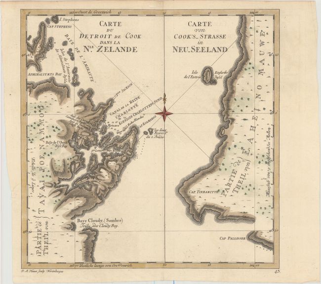
In 1768 Capt. James Cook sailed from England on his first round-the-world voyage, and after a year and a half sailing around Cape Horn to the Pacific Ocean, he sighted New Zealand's north island. On January 15, 1770 Cook's ship the Endeavour sailed into a deep water inlet surrounded by thick wooded hills, and anchored in a snug harbor where the ships was to be repaired, scraped and caulked. After surveying the harbor, Cook declared it Queen Charlotte Sound and took possession of it in the name of the Crown. Upon climbing a high hill above the harbor, Cook saw that he was standing at the entrance to a strait, not a bight as Abel Tasman has assumed during his voyage of 1642. On February 7th, the Endeavour set sail through the strait to which Cook gave his own name. This fine sketch was brought back to London by Cook after the voyage, and shows Queen Charlotte Sound, Admiralty Bay, and Partie de Tavai Poe Nammoo on the south side of the strait. The north side of the strait is labeled Partie de Eaheino Mauwe, where the city of Wellington is now situated. Engraved by Daniel Adam Hauer and published in a German edition of Hawkesworth's "Voyages Around the World Undertaken by the Order of His Present Majesty..."
References: Sabin #30943.
Condition: A
Issued folding on watermarked paper with minor printer's ink residue and a short binding tear in left blank margin that has been professionally repaired.