Subject: Polar
Period: 1769 (dated)
Publication: Atlas Universel pour l'Etude de la Geographie
Color: Hand Color
Size:
16.3 x 9 inches
41.4 x 22.9 cm
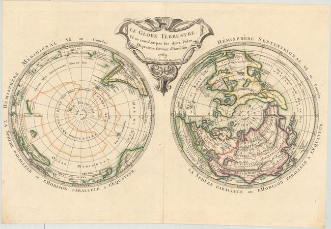
This rare map is depicted on Cassini's projection, with interesting geographical misconceptions. In the Northern Hemisphere there is a large Mer de l'Ouest with five small islands and Lac de Valasco nearly connecting with Hudson Bay. A large island in the vicinity of Alaska is named Presqu'Isle du Nord Ouest, and Greenland is connected to Canada. In the Far East, Hokkaido is quite distorted with the mythical I. de la Compagnie to the east. In the Southern Hemisphere parts of New Zealand and Australia are mapped, although conjectural coastlines connect Australia to both Tasmania and New Guinea and New Zealand appears connected to Antarctica. This is the second state, with the addition of a large island in Baffin Bay. Drawn and engraved by Maurille Antoine Moithey, with lettering by Herault. Published in Etienne Andre Philippe de Pretot's Atlas Universel.
References: McGuirk #139; Mickwitz & Miekkavaara #179-6; Tooley (Australia) p. 188, #1528.
Condition: B+
A crisp impression with attractive color and two small spots in the title cartouche. Margins trimmed close to image at left.