Subject: Hispaniola & Puerto Rico
Period: 1745 (circa)
Publication:
Color: Hand Color
Size:
40.4 x 23.4 inches
102.6 x 59.4 cm
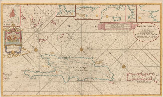
This magnificent large chart of Hispaniola and Puerto Rico was published by Johannes van Keulen II, who led the Van Keulen firm from 1726 until his death in 1755. The chart was compiled from the chart made by Amedee Francois Frezier, Ingenieur ordinaire du Roy on Hispaniola, published by Guilaume Delisle in Paris (1725). Van Keulen translated it for navigation and added new hydrographical information provided by Captain Hendrik Lijnslager, a Dutch naval officer, to whom the chart is dedicated. Five inset coastal charts, an inset plan of Santo Domingo City with a numbered key to major sites and monuments, and a superbly decorative dedication cartouche make this a very handsome map. Printed on two sheets, joined, as issued.
Dutch naval activity in the Caribbean increased in the early part of the 18th century, due to a dispute with Spain over trade routes and from Spanish-American pirates. Captain Hendrik Lijnslager, of the Amsterdam Admiralty, explored several Caribbean-Atlantic sailing routes, eventually recommending a westerly route that was popular with English seaman. During his expedition, Lijnslager used a prototype of the Frezier-Van Keulen chart and had high praise for its accuracy. The chart was published between 1741, after Lijnslager's return to Amsterdam, and 1748 when he was promoted to Rear Admiral.
References:
Condition: B+
Nice example with narrow margins, as is usual with large sea charts. A few small stains in image.