Subject: Gulf of Mexico, Florida & Peru
Period: 1584 (published)
Publication: Theatrum Orbis Terrarum
Color: Hand Color
Size:
18.1 x 13.1 inches
46 x 33.3 cm
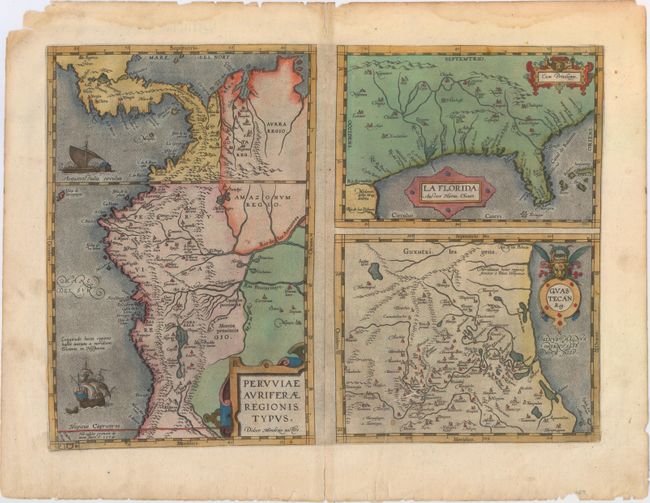
This was one of the few sixteenth century maps based on Spanish sources; in this case drawing from reports of Hernando de Soto's expedition through the region. There are three maps on this sheet. The most important map, La Florida, is the first printed map of the southern portion of the United States. This influential map provided the foundation cartography for the region, particularly in the depiction of the river system. The map below (Guastecan Reg) combines with La Florida to extend the coastline of the Gulf of Mexico further south. The third is a map of Peru, where De Soto was the first Spaniard to meet Inca Emperor Atahuallpa. In the north of the map of Peru is Aurea Regio, or Kingdom of Gold, a reference to the fabled El Dorado. All maps contain decorative cartouches, and the map of Peru is embellished with two ships. German text on verso with page number 8 at top right. According to Van den Broecke, there were only 75 copies printed of this edition.
References: Burden #57; Cumming (SE) #5; Van den Broecke #15.
Condition: B+
A strong impression on watermarked paper with an edge tear that extends 2" into the map image at lower right that has been closed on verso with archival material. Closed centerfold separations at top and bottom do not enter map image. Several other small edge chips, edge tears and a damp stain at top are all confined to the blank margins.