Subject: Texas
Period: 1870-90 (circa)
Publication:
Color:
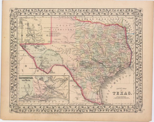
A. County Map of Texas, by S. Augustus Mitchell Jr., dated 1870, hand color (13.6 x 10.7"). One of the most attractive maps of the state of Texas, inset with a map of Galveston Bay, and Vicinity. West Texas is made up of Young Territory, Bexar Territory, El Paso and Presidio counties, and clearly shows the Llano Estacado or Staked Plain with a notation about the region being "destitu[t]e of both wood and water." Erath County is mistakenly identified as "Earth" County. The map shows trails, roads, a limited railroad system that extends only into Austin, and proposed railroads indicated by dashed lines. The map is surrounded by a fine floral border. Copyright date 1860, published circa 1864. The county development is up-to-date for 1864 as Dawson County, abolished in 1866, is included Condition: A few short edge tears and chips confined to the blank margins. (A)
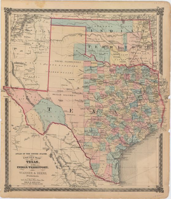
B. County Map of Texas, and Indian Territory, by Warner & Beers, from H.H. Lloyd & Co.'s Atlas of the United States, circa 1875, hand color (15.4 x 17.1"). This is the only map of Texas that we are aware of that shows the proposed Wigefarth County in the lower Panhandle along the border of Indian Territory. The county line is only partially engraved with the northern border defined in color alone. The existing network of roads, trails and railways is minutely detailed and includes several railways that were not actually completed. Indian Territory is divided among eleven Native nations. Published by H.H. Lloyd & Co. Condition: Light soiling with several edge tears that just enter map image closed on verso with non-archival tape. (B)
C. Texas, New Mexico &c., by J. Bartholomew, circa 1890, printed color (15.7 x 11.3"). County development has taken place in the panhandle and dates circa 1890 with the additions of Deaf Smith, Hall and Floyd counties. Tom Green, Crockett, Pecos, Presidio and El Paso occupy the western portion of the state. Condition: A few minor spots of foxing. (B+).
References:
Condition:
See description above.