Subject: Southern California
Period: 1852-56 (dated)
Publication:
Color:
The Office of Coast Survey is the oldest U.S. scientific organization, dating from 1807 when Congress directed that a "survey of the coast" be carried out. By 1836, it was called the U.S. Coast Survey and in 1878, the name was changed to the U.S. Coast and Geodetic Survey. Today the Office of Coast Survey is a division of the National Oceanic and Atmospheric Administration NOAA.
The survey teams, composed of civilians as well as Army and Naval officers, charted the nation's waterways and produced a wide array of reports, survey charts, hydrographic studies of tides and currents, astronomical studies and observations, and coastal pilots. These charts are an important record of the changing nature of the nation's coastlines. In additional to coastal charts, the U.S. Coast and Geodetic Survey produced land sketches, Civil War battle maps, and the early aeronautical charts.
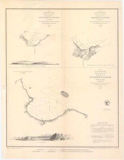
A. Reconnaissance of San Clemente Harbor California... [on sheet with] Reconnaissance of Prisoner's Harbor... [and] Reconnaissance of Cuyler's Harbor..., dated 1852, black & white (13.6 x 16.8"). This sheet includes three handsome charts of harbors in Southern California: San Clemente Harbor, Prisoner's Harbor on Santa Cruz Island, and Cuyler's Harbor on San Miguel Island. Each features nice topographical detail, bottom types, soundings, and anchorages. The San Clemente chart has a view of the northwest end of the island, and a view of Cuyler's Harbor appears on that chart. Sailing directions are located in the bottom right corner. Reduced for engraving by E. Hergesheimer, with outlines, topography, and views engraved by Max. F.O. Strobel. Lettering by Samuel E. Stull. Condition: A nice impression issued folding with minor offsetting, very faint toning along the folds, and a couple of tiny holes, only visible when held to light. A binding trim at bottom left has been replaced with old paper, and the sheet has been backed in Japanese tissue.
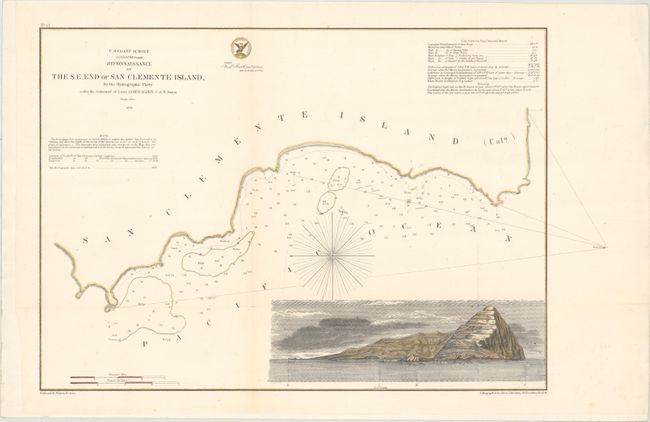
B. Reconnaissance of the S.E. End of San Clemente Island, by the Hydrographic Party..., dated 1856, hand color (18.8 x 12.1"). This chart details the coastline, bottom types, and soundings of San Clemente Island. The large inset is a sea view of the island with a sailing ship anchored offshore. A table detailing the tides appears in the top right corner. Issued by the Hydrographic Party under the command of Lieut. James Alden, USN. Reduced by Wilson Fairfax and lithographed by James Ackerman. Condition: A nice impression with some tiny faint spots. Issued folding, now backed in paper to repair a short fold separation near the inset.
References:
Condition: B+
See description above.