Subject: Eastern United States
Period: 1846 (dated)
Publication:
Color: Hand Color
Size:
33.8 x 24.5 inches
85.9 x 62.2 cm
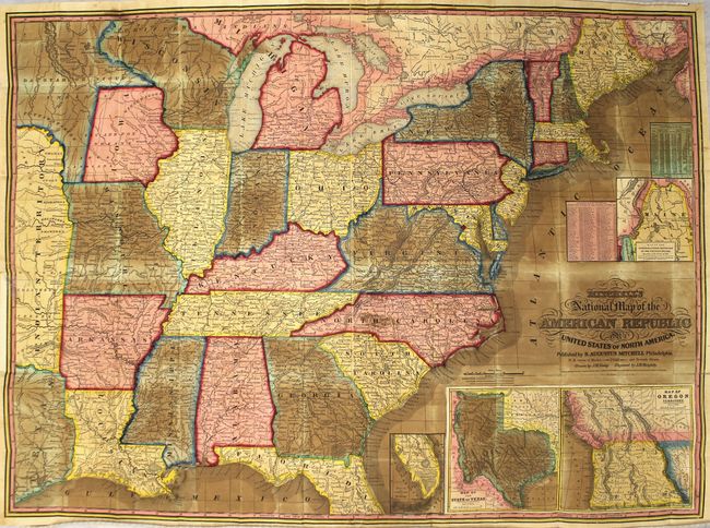
This second edition pocket map was drawn by J.H. Young and engraved by J.H. Brightly. It extends into Texas, Indian Territory, and a large unorganized area labeled Dacotah or Sioux Indians. Large insets within the map include the new State of Texas (with its largest borders), a "Map of the North-Eastern Boundary of the United States according to the Treaty of 1842" which details the Webster-Ashburton Treaty, and another detailing Oregon Territory which shows the territory extending well into Canada. The map is very detailed with hundreds of place names, plus roads, villages, railroads, ports, etc. A table gives the 1840 population for 120 cities and another gives the states' population of Whites, Free Blacks and Slaves. The state of New Hampshire is listed with only one slave. The map folds into black morocco boards with gilt title on front cover and functioning brass clasp, and is accompanied by the 42-page "A Route-Book, Adapted to Mitchell's National Map of the American Republic..."
References:
Condition: C+
Original color with moderate toning and oxidation of the blue and green pigment. There are numerous fold separations along the folds that have been closed on verso with archival tape as well as a 1.5" binding tear at left that has been closed on recto. Despite the toning, the sheet is quite supple. Covers are moderately worn.