Subject: World
Period: 1680 (circa)
Publication:
Color: Hand Color
Size:
22.8 x 19.2 inches
57.9 x 48.8 cm
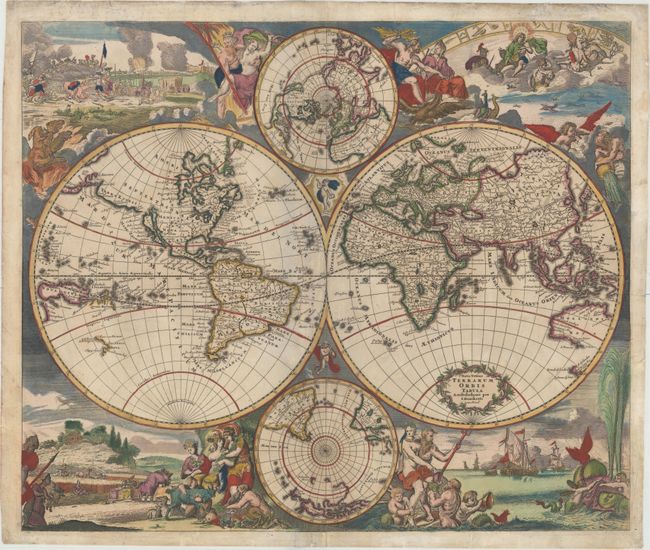
This is Danckerts' version of De Wit's splendid maritime world map. The cartographic features include the island of California and open-ended Great Lakes on the Sanson model in North America. A remnant of Lake Parime is still shown in South America. In Africa, the Nile still rises from twin lakes and the interior is mostly guesswork. In Asia, Australia is represented only by the northern and western coastlines and Van Diemen's discoveries are shown in Tasmania and New Zealand. Above and below the map are polar projections, with only the tip of South America shown in the Antarctic sphere. Lively allegorical scenes representing the four elements surround the map. Fire is depicted by a fierce battle scene and the abduction of Persephone; air as the heavenly realm ruled by Zeus and Hera; water by Neptune with his entourage, sailing ships and a fantastic spouting whale; and earth by Demeter and two other earth goddesses in a peaceful scene of harvesting and husbandry. This is Danckerts' first of two similar maps, with geography identical to De Wit's original.
References: Shirley #495.
Condition: B+
A crisp impression with attractive original color that has been refreshed and marginal soiling. There are professional repairs to a 1" tear adjacent to South America, a 1" centerfold separation at bottom, and a tear that enters 1/2" into map at right. There are additional chips and tears confined to blank margins that have also been professionally repaired. A lovely example.