Subject: History Books
Period: 1787 (published)
Publication:
Color: Hand Color
Size:
9 x 11.6 inches
22.9 x 29.5 cm
This fascinating history of the Southern Theater of the American Revolution is told from the perspective of the British. General Banastre Tarleton, commander of the British Legion, served in America from May 1776 to October 1781. Tarleton played an important role in the capture of Charleston and the brutal Battle of Waxhaw Creek, and returned to Britain after the failed Siege of Yorktown. This history is highly regarded for its use of original documents, which are included in the notes following various chapters. Also included are five important maps:
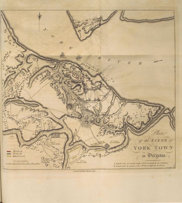
A. Plan of the Siege of York Town in Virginia, March 1, 1787 (12.6 x 11.4"). This important and well-engraved map served as the basis for many later maps of the Siege of Yorktown, including for Stedman's History of the Origin, Progress, and Termination of the American War. The positions of the British (red), American (yellow), and French (blue) troops are shown along with notations of the commanding officers. The critical ravines and creek beds used during the battle are well depicted, and the redoubts taken by the French and Americans are marked. The headquarters of General Washington and Rochambeau is depicted at bottom left. In the York River, the ships Charon and Guadeloupe, as well as many sunken vessels are noted along with lines of fire. Condition: Faint offsetting and minor toning. (B+)
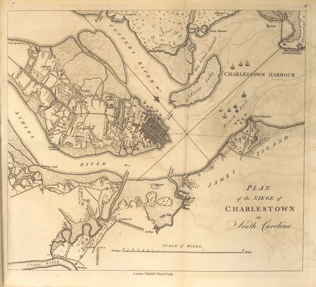
B. Plan of the Siege of Charlestown in South Caroline, March 1, 1787 (11.5 x 10"). Tarleton's plan of the Siege of Charleston depicts the British ships and encampments surrounding the city. The deployment of British units on the peninsula north of the city are shown, along with three parallels of the siege. The boom erected between Charleston and Shute's Folly is also depicted. Condition: Light offsetting. (B+)
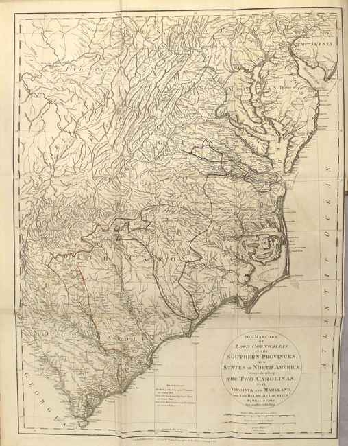
C. The Marches of Lord Cornwallis in the Southern Provinces, now States of North America; Comprehending the Two Carolinas, with Virginia and Maryland, and the Delaware Counties, by William Faden, Feb. 3, 1787 (19.2 x 25.3"). As the title states, this map depicts the entire Southern Theater of the war from Pennsylvania and New Jersey to South Carolina. There is excellent detail of towns, roads, courthouses, Indian settlements, and topography. The routes of Cornwallis, O'Hara, and Tarleton are outlined in red, blue and yellow, as indicated by the key adjacent to the title. Condition: Faint offsetting with a 1/2" binding tear at right. (A)
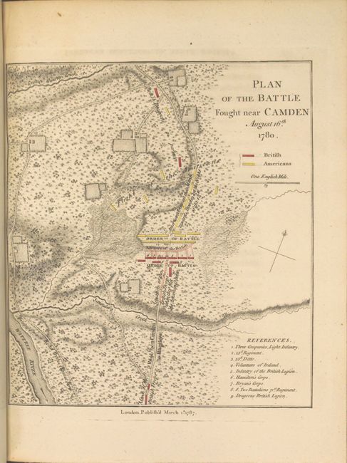
D. Plan of the Battle Fought Near Camden August 16th 1780, March 1, 1787 (7.3 x 8.3"). This battle plan gives excellent detail of the terrain and depicts the British in red and the Flight of the Americans in yellow. A numbered key at bottom right identifies the various British regiments. Condition: Clean and bright. (A)
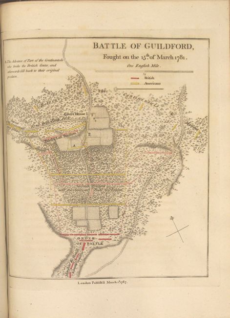
E. Battle of Guildford, Fought on the 15th of March 1781, March 1, 1787 (7.4 x 8.3"). In this battle plan the initial position of British forces are shown in red with the second and third positions shown in pink. American forces are depicted in yellow, with their various stages illustrated using large, yellow rectangles. Condition: Minor offsetting from opposing page of text. (A)
Published by T. Cadell in London. Quarto, vii, 518 pp., 1 leaf advertisement at end. Hardbound in quarter leather with tips over marbled-paper boards, raised bands with gilt tooling and black leather title label on spine. Housed in modern custom blue cloth chemise and slipcase with faux leather spine and gilt title.
References: Howes #T37; Nebenzahl (Biblio. Amer. Rev.) #60, #83, #90, #92, #197; Nebenzahl (Atlas Amer. Rev.) #41, #42; Sabin #94397.
Condition: A
Overall this is an exceptional example of this work. Contents are crisp, clean and tight, with very occasional minor soiling. See below for condition of maps, which are in original outline color. Hinges are starting and extremities show minor wear. The elegant case is in excellent condition.