Subject: Pakistan & Afghanistan
Period: 1486 (published)
Publication: Cosmographia
Color: Hand Color
Size:
21.7 x 15.8 inches
55.1 x 40.1 cm
Claudius Ptolemy was a mathematician, astronomer and geographer who worked in Alexandria, then a part of the Roman Empire, in the 2nd century AD. One of the most learned and influential men of his time, his theories dominated both astronomy and geography for nearly 1500 years. His writings were kept alive by Arabic scholars during the Middle Ages and reemerged in Europe during the Renaissance. The birth of printing led to wide dissemination of his great works on astronomy and geography. There were a number of editions of his Geographia beginning in 1477. These early editions contained maps based on his original writings, known as Ptolemaic maps. As geographic knowledge increased with the explorations of Columbus, Magellan, Cabot and others, maps of the New World were added, and maps of the Old World were revised. Ptolemy's Geographia continued to be revised and published by some of the most important cartographers including Martin Waldseemuller, Sebastian Munster, Giacomo Gastaldi, Jodocus Hondius, and Gerard Mercator (whose last edition was published in 1730).
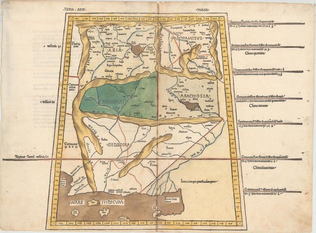
This striking woodblock map provides a Ptolemaic view of the region of present-day Pakistan, Afghanistan and northern India within a trapezoidal border. The historic regions of Gedrosia, Drangia, Aria, Paropanisus, and Arachosia are prominently located with their rope-like mountainous boundaries. Latin text on verso.
Donnus Nicolaus Germanus was a Benedictine monk, cartographer, and printer who served as the editor of the 1482 and 1486 editions of Cosmographia. In addition to editing Jacobus Angelus's Latin translation, he also corrected and improved the maps. Printed for Justus de Albano de Venetiis by Johann Reger from the same blocks as the first edition, with new headings over the maps and reset Latin text on verso. According to Nordenskiold, the 1486 edition of the atlas is significantly rarer than its predecessor.
References: Mickwitz & Miekkavaara #200-29.
Condition: B+
A nice impression with minor soiling and professional repairs to some binding holes and separations along the centerfold, as is common with this edition. Remnants of hinge tape on verso.