Subject: Western England
Period: 1831-85 (circa)
Publication:
Color: Hand Color
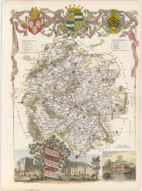
A. Herefordshire, by Thomas Moule, circa 1844 (7.4 x 10.3"). This fascinating small map shows the county of Herefordshire subdivided into its eleven hundreds. Centered on the city of Hereford, the map names a number of towns and delineates roads, parks, canals, and more. The map's title appears on a banner wrapped around a tree at bottom left in between views of Goodrich Castle and the Garnstone House. A view of the city of Hereford adorns the bottom right corner. The map is surrounded by a decorative border that culminates in drapes, flowers, crowns, and coats-of-arms at top.
Thomas Moule (1784 – 1851) was a writer, bookseller, publisher, topographer and a scholar in heraldry. His varied career led him in 1830 to produce a series of English county map based on his own travel. He wrote that he has “with expensive diligence personally visited every county in England, excepting only Devonshire and Cornwall.” His maps were delicately engraved on steel in a highly decorative style, featured such embellishments as armorial bearings, figures, fancy borders and vignettes of local interest. This amount of ornamentation in mapmaking was unusual for the period as most mapmaker’s were instead creating scientifically accurate, austere works. His series of county maps were originally published in separate sections for each county (1830-32), then subsequently published in a two-volume work: The English Counties Delineated…, (1836). Beginning in 1841, the maps appeared in Barclays Complete and Universal English Dictionary. Condition: Near fine.
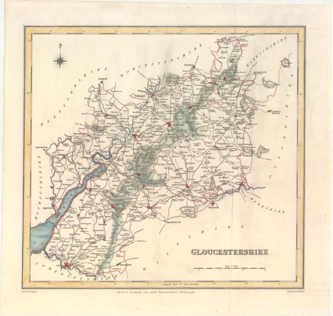
B. Gloucestershire, by Samuel Lewis, from Lewis' Topographical Dictionary, circa 1831 (9.9 x 9.3"). This small map of Gloucestershire features plenty of place names and nice topographical detail. Rivers, roads, and railways are traced. Thames Head is indicated by a small note reading, "Head of the River Thames or Isis." Drawn by R. Creighton and engraved by J. & C. Walker. Condition: There is minor soiling and some short edge tears confined to the blank margins.
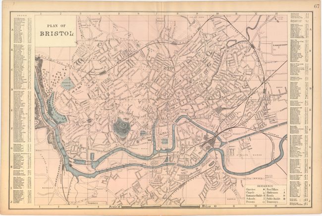
C. Plan of Bristol, by G.W. Bacon, circa 1885 (19.2 x 12.5"). This detailed plan of Bristol includes an index that locates various streets and locations in the city. Churches, schools, prisons, hotels, tramways, and more are located in addition to the roads, rivers, and railways delineated. Condition: There is toning along the sheet's edges and a few short edge tears, all confined to the blank margins.
References:
Condition: A
See description above.