Subject: World
Period: 1651 (dated)
Publication: Cartes Generales de Toutes les Parties du Monde...
Color: Hand Color
Size:
20.8 x 14 inches
52.8 x 35.6 cm
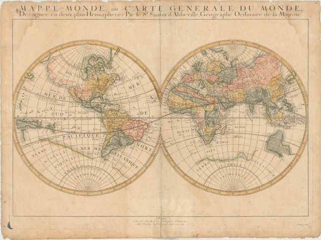
This is the first state of Sanson's first map of the world, showing California as an island. It is one of the first maps to distinguish the Great Lakes and name Lac Superior and Lake Michigan, here called Lac des puans (lake of evil smells). All five of the Great Lakes were not named until Sanson's 1656 map of New France. The northwest coast of North America extends far west to Asia, with the place names Anian, Quivira, Nouvelle Albion, and Sierra Nievada. The faint outline of Terra Magellanica appears in the south. Australia is only partially shown, and labeled simply Beach, with place names on the south and west coasts reflecting Dutch discoveries. Neither Tasmania nor New Zealand are shown. The map is typical of Sanson's "scientific" style of cartography with no decorative elements. It was published in conjunction with Pierre Mariette (father and son), who published many of Sanson's works after 1645. Engraved by Riviere.
References: Pastoureau, SANSON V A [1]; Shirley #390.
Condition: B
Original outline color with later wash coloring on watermarked paper with light toning and faint scattered foxing. There are short centerfold separations at top and bottom and light damp stains that enter the neatline in the top corners. Several short edge tears at top have been archivally repaired.