Subject: Africa
Period: 1692 (dated)
Publication: Atlas Nouveau
Color: Hand Color
Size:
34.4 x 21.1 inches
87.4 x 53.6 cm
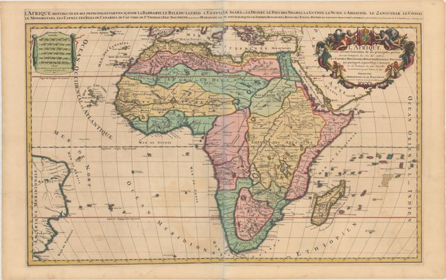
This striking map is the Mortier version of Jaillot's 1674 map of the continent of Africa. It can be distinguished from the earlier Jaillot map of Africa by the date and minor changes in the title in the top margin and it does not carry the engraver's imprint. Based on Sanson's second map of Africa (1668), it presents the standard Ptolemaic description of the source of the Nile. However, Jaillot introduced a new depiction of the rivers south of these Ptolemaic lakes. The Zambeze River appears above the Zambere and Rio de Spiritu Santo, all of which flow into the Indian Ocean. A large section of South America is shown and two St. Helena islands appear - a common error in maps from this period. The large distance scale cartouche has six scales. The very large and decorative title cartouche includes a tumult of figures, cornucopias, elephant, crocodile, lion and ostrich under the coat of arms of the Dauphin. Two sheets joined, as issued.
References: Betz #156.1; Norwich #46; Pastoureau, JAILLOT I D [4]; Tooley (MCC-47) p. 46, plt. #16.
Condition: B+
A crisp impression with lovely original color, light toning, and light offsetting. The slight bluish shadow along the joint in the image is a product of the scanning process and is not present on the actual map.