Subject: Southern France
Period: 1697 (dated)
Publication:
Color: Hand Color
Size:
56.8 x 23.3 inches
144.3 x 59.2 cm
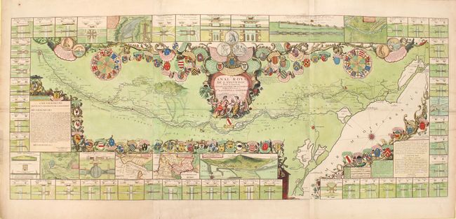
This impressive map on three joined sheets depicts one of the largest civil engineering projects of the seventeenth century. The desire for a Canal des Deux Mers (Two Seas Canal) that would connect the Mediterranean to the Atlantic Ocean goes back to antiquity, but proved too complex a project for hundreds of years. Finally in 1662, Pierre-Paul Riquet, a wealthy tax-collector in the Languedoc region, submitted a feasible proposal to King Louis XIV, who issued a royal edict in October 1666 to commence the project. The Canal Royal de Languedoc, now known as the Canal du Midi, was finally completed in 1681, connecting the Garonne River near Toulouse to the Etang de Thau on the Mediterranean. This map depicts the 150-mile canal, noting the numerous towns, rivers, and lakes along the route. The Black Mountain is prominently shown, which supplies the water for the canal and was a key challenge in developing the plan. The map is surrounded by 53 insets depicting aqueducts, locks, and other important features along the canal. The map is also handsomely embellished with an allegorical title cartouche, 58 coats of arms of those associated with the canal, and a medallion representing Louis XIV.
References:
Condition: B+
A nice impression with superb color and good margins. There are two 2" tears that enter the image at left and have been closed on verso with old paper, as well as a number of short tears confined to the blank margins that have been archivally repaired. Overall excellent condition for a map of this size.