Subject: Belgium & Luxembourg
Period: 1730 (circa)
Publication: The World Described; or, A New and Correct Sett of Maps
Color: Hand Color
Size:
39.9 x 24.3 inches
101.3 x 61.7 cm
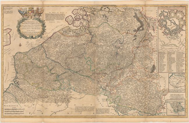
This handsome large map on two joined sheets depicts the Spanish Netherlands, comprised of Belgium, Luxemborug, and portions of Germany and France. It spans from Normandy up to the wetlands of De Biesbosch in the Netherlands and extends as far east as Trier in Germany. A plethora of towns and cities are named, and there is nice topographical detail as well. Soundings and banks are shown in the Strait of Dover and North Sea. In addition to numerous historical and geographical notes, there are three insets: an extensively labeled fortification plan, a map focused on various roads emanating from Paris, and another map of the southern portion of Luxembourg. A beautiful decorative title cartouche at top left features the Anglo-Norman maxim Honi soit qui mal y pence [sic] ("Shame be he who thinks evil on it"), a coat-of-arms, allegorical creatures, and symbols of military might. The imprints of John Bowles, Thomas Bowles, and John King appear at bottom right.
Herman Moll was one of Britain's most prominent cartographers of the first half of the 18th century. He emigrated from Germany and went to work as an engraver for Moses Pitt in 1678. Soon he joined one of London's most interesting social circles, which gathered at Jonathan's Coffee House, and included stock speculators, scientists, archaeologists, authors, pirates, and sea-captains. From these friends, Moll gained a great deal of privileged information that he compiled into his cartographic works. Moll's success and prosperity was due in part to his social connections and political astuteness, and to his distinctive style and quality workmanship. He produced a great number of often-innovative maps, charts, globes, atlases and geographies. His best known works are the large two-sheet maps produced for his World Described, which were also published separately.
References: Shirley (BL Atlases) T.MOLL-4b #22.
Condition: B
A nice impression with light toning along the folds, light offsetting, and minor soiling. There are some long fold separations and tears that have been repaired with archival materials.