Subject: Hawaii
Period: 1784 (dated)
Publication: The Geographical Magazine…
Color: Black & White
Size:
12.6 x 7.6 inches
32 x 19.3 cm
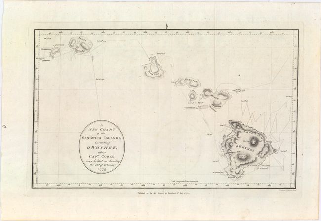
This uncommon chart is Harrison's version of Henry Roberts' chart, which is considered the first printed chart of Hawaii. Roberts' chart appeared in the official account of Cook's voyages, first published in June 1784. Harrison's chart was published just one month later in William Frederick Martyn's (a pseudonym for William Fordyce Mavor) The Geographical Magazine; or, a New, Copious, Compleat and Universal System of Geography, printed for Harrison & Co. In contrast to Roberts' chart, Harrison omits the inset of Kealakekua Bay and focuses instead on the path of the Resolution and the Discovery when Captain Cook first visited the Sandwich Islands in January 1778. The chart also notes his second visit to the islands in February 1779, when he was killed by the natives at Kealalekua Bay on the Big Island of Hawaii (Owhyee). The islands appear with good topographical detail and a few place names, including the volcanoes Mauna Kea (Mowna Kaah) and Mauna Loa (Mowna Roa) on the main island. At around 2,000 square miles, Mauna Loa is considered to be the largest volcano on earth. Engraved by T. Woodman and H. Mutlow.
Interestingly, the engraving of the lettering on Roberts' chart is attributed to William Harrison (circa 1750-1803). Although we were not able to determine a relationship between William and John Harrison, the coincidence is certainly intriguing.
References: McCorkle (18th C. Geography Books) #268-23; Shirley (BL Atlases) G.MRT-1a #30.
Condition: A
A nice impression issued folding on watermarked paper with minor offsetting.