Subject: Monterey, California
Period: 1852 (dated)
Publication: Report of the Superintendent of the United States Coast Survey
Color: Black & White
Size:
11.7 x 13.1 inches
29.7 x 33.3 cm
The Office of Coast Survey is the oldest U.S. scientific organization, dating from 1807 when Congress directed that a "survey of the coast" be carried out. By 1836, it was called the U.S. Coast Survey and in 1878, the name was changed to the U.S. Coast and Geodetic Survey. Today the Office of Coast Survey is a division of the National Oceanic and Atmospheric Administration NOAA.
The survey teams, composed of civilians as well as Army and Naval officers, charted the nation's waterways and produced a wide array of reports, survey charts, hydrographic studies of tides and currents, astronomical studies and observations, and coastal pilots. These charts are an important record of the changing nature of the nation's coastlines. In additional to coastal charts, the U.S. Coast and Geodetic Survey produced land sketches, Civil War battle maps, and the early aeronautical charts.
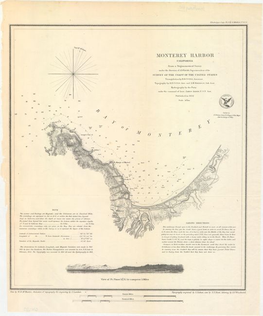
This great chart from the important coastal survey of Monterey Bay features a plan of the town and fort. A church, custom house, ruins of a fortified Mexican battery, Point Pinos, Pt. Anlon, Pt Almejor Mussell, a lagoon, and the cemetery are located. It extends to Point Pinos, now the location of Pacific Grove and part of the famous 17 Mile Drive, with a small offshore view of Pt. Pinos across the bottom. The chart includes extensive sailing directions, a simple compass rose, two distance scales, and the official seal of the Coast Survey Office. The topography was reduced for engraving by J. Lambert and engraved by S. Siebert, the views by S.V. Hunt and W.B. McMurtrie, and the lettering by E.F. Woodward.
References:
Condition: A
A crisp impression, issued folding, with a couple of tiny spots foxing, a mis-fold at bottom left, and some tiny chips and tears in the left blank margin where the map was removed from the report (not included).