Subject: Eastern United States, Texas
Period: 1845 (circa)
Publication: National Atlas
Color: Hand Color
Size:
24.3 x 19.8 inches
61.7 x 50.3 cm
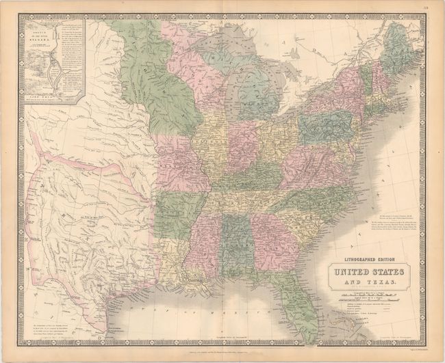
This handsome and very detailed map of the eastern United States features the independent Republic of Texas. Typical of British maps of this period, the map is densely engraved with information including an incredible network of roads and trails, built and proposed railways, operational and proposed canals, and lighthouse locations. The territories of Wisconsin and Iowa are both depicted, with Iowa stretching between the Mississippi and Missouri Rivers and extending to the Canadian border. Texas is shown with its borders extending from the Rio Grande to the Arkansas, encompassing Santa Fe and even beyond Pike's Peak. All of the important settlements in Texas are noted including all the communities along the Rio Grande. A note in the bottom left corner states "The Independence of Texas was formally declared in March 1836. It was recognized by Great Britain in Novr. 1840; and has been acknowledged by the United States, France, Holland and Belgium." In the upper left corner is an inset Sketch of the River Niagara. There is a note in the Atlantic regarding the Slave-holding States.
References: Day #1431.
Condition: A
Original color with a few minor spots along the centerfold at bottom and light toning along sheet edges, away from map image. There is a small damp stain confined to the bottom blank margin. Backed with very thin linen, apparently as issued.