Subject: United States
Period: 1822 (circa)
Publication:
Color: Hand Color
Size:
17 x 10.5 inches
43.2 x 26.7 cm
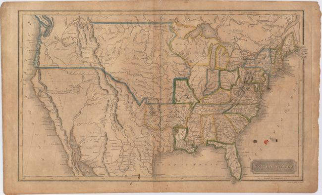
The United States and Great Britain established in 1818 joint claim over the Oregon Territory - the region north of Spanish controlled Upper California up to the southern boundary of Russia's Alaska Territory at North latitude 54°40'. By the late 1830's this arrangement was beginning to fall apart.
In the 1840's the expansionist Democrats, including their 1844 presidential candidate, James Polk, claimed the entire region for the United States. Their expansionist desires were expressed by Polk's famous campaign slogan, "Fifty-four Forty or Fight!" The slogan also became a rally cry for Americans desiring to settle the territory. Following Polk's election, the dispute was resolved by the 1846 Treaty of Oregon, which struck a compromise that fixed the U.S./Canadian boundary at 49º North.
This uncommon map of the United States was engraved by Annin & Smith and published in Boston. Arkansas is in it's large configuration extending to Mexico, while Texas is named and is part of Mexico. The large North West Territory is bounded on the west by the Mississippi River and stretches to lakes Superior and Michigan. The central plains and Northwest are labeled Missouri Territory. The border between the United States and Canada stops in Montana, reflecting the disputed boundary between the U.S. and Britain in the Pacific Northwest. An unknown river bisects the unnamed Great Basin with a hopeful notation predicting it "will probably be the communication between the Atlantic and Pacific."
References:
Condition: B
Original color with light to moderate toning, a faint damp stain at right, a tiny centerfold separation at top, and moderate soiling.