Subject: Northeastern United States & Canada
Period: 1793 (circa)
Publication: Morse's American Universal Geography
Color: Hand Color
Size:
16 x 12.5 inches
40.6 x 31.8 cm
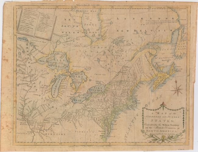
This uncommon and information-packed map describes the region from James Bay to Chesapeake Bay and the confluence of the Mississippi and Ohio Rivers, and from the Lake of the Woods to the Gulf of St. Lawrence. An explanation of the various symbols used in the map are displayed in the form of an open book in the upper left corner. Several of the districts and states are shown with distorted borders, but the most interesting feature of the map are the numerous Bounty Land Grants shown in the western frontier including Genl Clarks, Donation Lands from the Commonwealth of Virginia, and Ohio Company in Ohio, and Wabash Company, New Jersey Company, and Illinois Company in Illinois.
References: McCorkle #789.6; Kershaw #386; Sellers & Van Ee #194; Wheat & Brun #153.
Condition: B
Issued folding and now pressed with archival repairs to several short fold separations and tiny holes at fold intersections. There is scattered foxing and a 1.5" edge tear at top that has been closed on verso with archival material. Binding trim at lower right has been replaced with old paper and an adjacent 2" binding tear has also been archivally repaired.