Subject: North Pacific Ocean
Period: 1758 (dated)
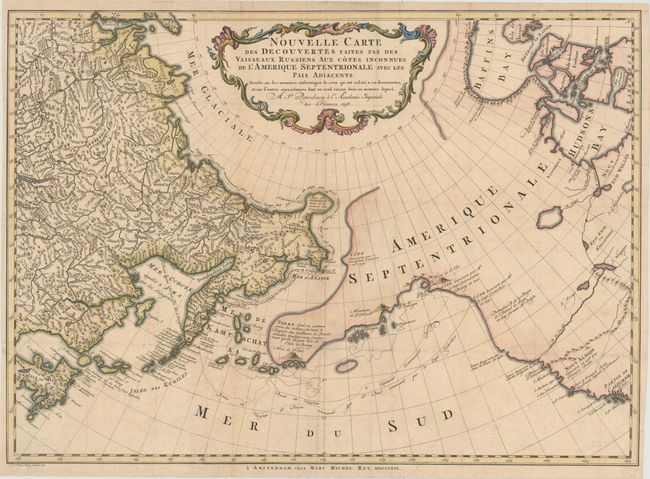
Publication: Voyages et Decourertes Faites par les Russes
Color: Hand Color
Size:
25 x 17.9 inches
63.5 x 45.5 cm
This is an uncommon Dutch edition of Gerhard Muller's landmark map of 1754 showing the discoveries of Captains Bering and Tschirikow. Muller was a German scholar who worked for the Russian Imperial Academy of Sciences. He originally published his map in response to Joseph Delisle and Philippe Buache's map that showed previously unknown Russian discoveries and an elaborate (and entirely speculative) depiction of the imaginary voyage of Admiral De Fonte through a Northwest Passage. Muller's map shows an elongated landmass roughly in the shape of the Alaskan Peninsula and the Aleutian Islands. The speculative Northwest Passage is shown nearly connecting to Hudson Bay via a mythical River of the West. Muller's map was copied numerous times by different publishers due to increased interest in the region and the De Fonte controversy. This edition was published in 1766 by Marc Michel Rey in Amsterdam with minor changes to the title cartouche and publishing information has been added in the bottom margin. A rare and fascinating addition to any collection of the Pacific Northwest. Printed on two joined sheets, as issued.
References: Falk #1758-1; Hayes #40; Wagner #591.
Condition: B+
Issued folding on watermarked paper with minor soiling, a few tiny separations that have been archivally repaired, and a short tear that just enters neatline at left that has also been archivally repaired. Narrow side margins.