Subject: Western Africa
Period: 1596 (circa)
Publication: Itinerario…
Color: Black & White
Size:
21 x 15.5 inches
53.3 x 39.4 cm
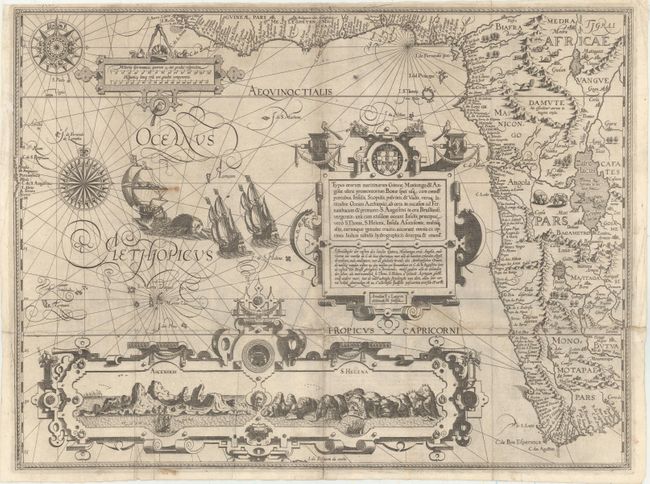
This is one of the most richly ornamented maps in early cartography, superbly engraved in the Flemish style by Arnold Florent van Langren. The cartouche contains a description of the region in both Latin and Dutch that credits the source as "the very best Indian maps" - referring to maps that Linschoten had access to when he was Secretary to the Portuguese Archbishop of Goa in India. The map covers the southwestern coast of Africa from the Gulf of Guinea to just beyond the Cape of Good Hope with excellent detail along the coastline. The fictitious cities of Vigiti Magna and Monomotapa are located and most place names and geographical features have Portuguese nomenclature. The mainland is embellished with snakes, an elephant, a rhinoceros, a lion and a pair of sirens in Lake Zaire. The balance of the sheet is filled with fabulous cartouches, the Portuguese arms, elaborate compass roses, sailing ships and a sea monster. The large bottom cartouche encloses views of Ascension and St. Helena Islands; important refueling ports in the route around Africa.
References: Norwich #239a; Tooley (MCC-29) #167; Tooley et al (Landmarks) pp. 168-69.
Condition: B
A fine impression with a few spots of soiling. Issued folding with old paper repairs to some short separations and tiny holes and tears primarily along the horizontal fold near the Tropic of Capricorn. A 3" tear extending from the Tropic of Capricorn to the title cartouche has also been archivally repaired.