Subject: Amsterdam, Netherlands
Period: 1748 (circa)
Publication:
Color: Black & White
Size:
15 x 6.75 inches
38.1 x 17.1 cm
Thomas Jefferys was one of the most important English map publishers of the 18th century. His work included prints and maps of locations around the world, but his most notable maps are of North America and the West Indies. He began his career in the map trade in the early 1730s, working as an engraver for a variety of London publishers, and eventually setting up his own shop. In 1746, he was appointed Geographer to the Prince of Wales, and in 1760 he became Geographer to the King. These titles granted access to manuscripts and cartographic information held by the government. In the early 1760s he embarked on an ambitious project to produce a series of English county maps based on new surveys, but ran out of money and filed for bankruptcy in 1766. He then partnered with London publisher Robert Sayer, who reissued many of Jefferys plates and continued to issue new editions after Jefferys' death in 1771. Jefferys' American Atlas and the accompanying West-India Atlas, published post posthumously, are considered his most important cartographic works.
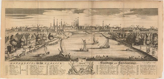
A fine panoramic view of the city with good detail of daily life including boats in the foreground loading supplies, people strolling along the waterway, and numerous boats under sail. Windmills surround the city. At bottom is a list of 42 major buildings and fortifications, all keyed to the engraving. Decorative title cartouche at center.
References:
Condition: B+
Issued folding with very light toning and minor soiling.