Subject: World
Period: 1791 (published)
Publication:
Color: Hand Color
Size:
20.4 x 14.6 inches
51.8 x 37.1 cm
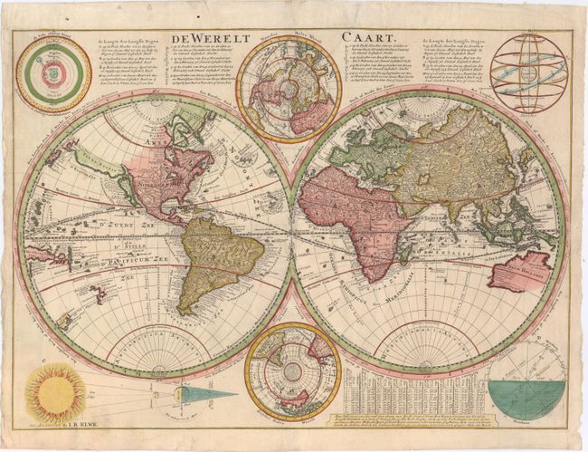
This is Cornelius Danckerts' second world map; his first being a re-engraved version of his father's map. This map is presented in the new scientific style popular at the turn of the 18th century. Danckerts retained the continental outlines from his father's map, including the island form of California. However, he updated information on the course of the Mississippi from recent French discoveries. Terra Esonis stretches across the Pacific from just above California nearly to Asia and the land of Yedso above Japan. Tasman's discoveries relating to Australia, New Zealand and Tasmania are shown in the Pacific. North and south polar projections appear at the top and bottom between the spheres. In each upper corner are illustrations of the Ptolemaic theory on the revolution of the planets and stars around the earth. In the lower corners are diagrams of the movement of the Sun throughout varying degrees of latitude, and a plan of the Sun, Moon and Earth during lunar and solar eclipses. There are extensive notations in Dutch at the top and a keyed table of latitude at the bottom. This is a later version published by Jan Barend Elwe; his imprint at bottom left has replaced that of Danckerts. Shirley does not mention this edition, but Poortman & Augusteijn note that Elwe published Danckert's Bible in 1791.
References: Shirley #615; Poortman & Augusteijn #159.
Condition: B+
Nice color on watermarked paper with minor stains at left and a professionally and nearly invisibly repaired tear that enters 7" into image at top.