Subject: Niagara Falls, New York
Period: 1890 (published)
Publication:
Color: Printed Color
Size:
6 x 9.5 inches
15.2 x 24.1 cm
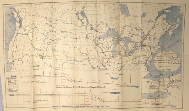
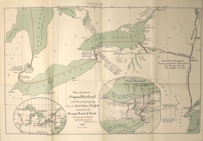
This 24-page report, prepared by William Pierson Judson of the American Society of Civil Engineers, demonstrates the need for a shipping canal around Niagara Falls on the basis of economic growth. His conclusion is based in part on the growth seen from similar canals constructed on Lake Superior and Huron and would be a better, bigger alternative to the Canadian Welland Canal. Included is a 12-page report from C.F. Palrey, issued in 1889. The report contains the following two maps that demonstrate two possible paths for a canal: Maps Showing the Locations of Proposed Niagara Ship Canal (between Lake Erie and Lake Ontario) and of the Connecting and Competing Ways from The West &c North West to the Sea (28.2 x 16.5") and Maps of Proposed Niagara Ship Canal with the Connecting Ways from the Great Lakes to New York (20.5 x 13.2"). Hardbound in brown cloth with gilt title on front cover.
References:
Condition: B+
Maps are clean and bright with a few short splits at fold intersections. Text is clean and bright and has separated from the binding. Covers are very good.