Subject: Washington, D.C.
Period: 1795 (circa)
Publication:
Color: Black & White
Size:
21 x 15.8 inches
53.3 x 40.1 cm
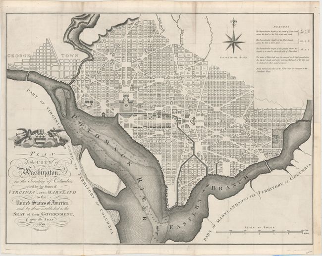
This map is based on the 1792 plan published by Andrew Ellicott. It is one of nine maps published in London as part of John Reid's An American Atlas, and engraved by John Russell of London. The same nine maps were included in An Historical, Geographical, Commercial and Philosophical View of the American United States by William Winterbotham (1763-1829) published in London in 1795 and 1799 and in New York in 1796. Reid's An American Atlas was meant to accompany the version of Winterbotham's history published without the maps. This undated Russell plan is among the larger of the maps issued during the city's development.
The plan shows the layout of streets including the long diagonals. Washington is bordered by the Potomack (Potomac) River and the Eastern Branch, now the Anacostia River. Georgetown, at the left and northwest of Rock Creek, is separately labeled. Reedy Branch and Tiber Creek are shown to the north outside of the street pattern. Each block is numbered. A few major buildings including the Capitol and the Presidents House are labeled; others are merely outlined. The proposed landscape design for the Mall is shown with considerable detail. Outline contours of docks and slips are shown along the rivers. Near the upper right is an eight-pointed compass indicator surmounted by a fleur-de-lys. Above the title is George Washington’s coat of arms supported by Fame and Liberty. At the lower right is a distance Scale of Poles. Remarks in the upper right lists the elevation of various locations in relation to the tide of Tiber Creek and how water could be provided to the city.
References: Phillips (DC) #PW 33; Phillips (M) p. 1005.
Condition: B+
Issued folding and now flattened with faint offsetting, minor soiling, and a few tiny splits at fold intersections that have been professionally repaired. There is a 2" binding tear at right that has been expertly repaired on verso and a binding trim at lower right replaced with old paper.