Subject: United States
Period: 1854 (circa)
Publication:
Color: Hand Color
Size:
48.4 x 31 inches
122.9 x 78.7 cm
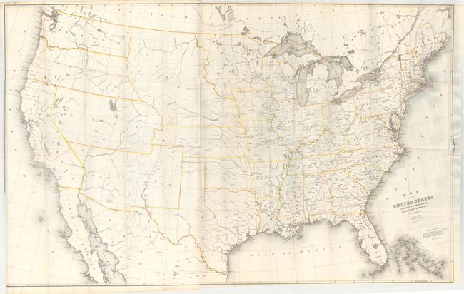
This huge map was issued just after the Gadsden Purchase and prior to the monumental undertaking of the Pacific Railroad Survey. It shows the United States with large western territories. New Mexico and Utah extend to California, while the continental divide marks the borders for Kansas, Nebraska, Washington and Oregon. Minnesota extends to the Missouri River and Indian Territory is defined but not named. Red overprinted lines indicate the customs collection district boundaries and yellow ones distinguish the states and territories. Lithographed by Ackerman in New York, printed on two joined sheets of fine banknote paper, as issued.
The map was drawn by David H. Burr, a tremendously important figure in the mapping of the United States. He began his career surveying in New York in 1829. He then went on to serve as topographer of the United States Post Office, Geographer for the House of Representatives, surveyor to the states of Florida and Louisiana, Geographer to the U.S. Senate and finally as Surveyor General of Utah Territory during the legal and jurisdictional disputes between Mormon leaders and the U.S. government. On this map he is credited as Draftsman U.S. Senate.
References:
Condition: B+
A clean and bright example, issued folding, with a binding trim at left that is trimmed to just inside the neatline at bottom and a 2.5" fold separation along the right border.